


 Art & Design
 Auto & Vehicles
 Beauty
 Business
 Education
 Entertainment
 Finance
 Food & Drink
 Health & Fitness
 House & Home
 Libraries & Demo
 Maps & Navigation
 Medical
 Music & Audio
 Parenting
 Personalization
 Photography
 Productivity
 Shopping
 Social
 Sports
 Tools
Tools Travel & Local
 Video Players
 Weather
 Family


 AIS Flytomap GPS Chart Plotter
OS :
Version :1.0.4.6.8
Size :
Updated :Jun 1,2022
Developer :FLYTOMAP INC
 Ask AI
You can ask
the AI some questions about the app
Here are three topics that users may discuss online about the app, turned into questions for you:
1. How does the app's satellite imagery and data processing affect its accuracy in marine navigation?
2. Are there any additional features or subscription plans that offer more detailed marine charts or AIS vessel tracking?
3. Have you experienced any issues with the app's compatibility with your device or internet connectivity while using it for navigation?
 Ask AI
Pros and Cons from users' feedback
After analyzing the user reviews on the Google Play Store, here are three cons and pros of the app:
**Pros:**
1. "Accurate marine navigation information helps me plan my sailing trips efficiently."
2. "User-friendly interface and clean design make it easy to use on the go."
3. "Offline maps are super convenient, allowing me to navigate even without internet."
**Cons:**
1. "Occasional crashes and freezing issues can be frustrating, especially in critical situations."
2. "Limited customization options for maps, which can be restrictive for some users."
3. "No clear instructions for setting up and connecting with device GPS, can be confusing."
Note: The reviews are subject to change over time, and this analysis is based on a snapshot of the reviews at the time of my analysis.
App
Downloads
<
>


App
Survey
-
Does the frequency of application notifications affect the experience?
-
What is your Mobile System?
-
Where do you get the new APP
-
Why do you uninstall an app?
Description
Live AIS now available
Real time map view of your boat and boats near you, worldwide.
No AIS receiver required, just your mobile!
Various icons depict different vessel categories.
Select any target to see vessel details such as name, MMSI, IMO, call sign, status, speed, heading, coordinates, distance from your GPS location, and more.
Flytomap offers within this app a subscription for a professional GPS chart plotter for only 4.99 USD.
At a glance
Worldwide Marine and Outdoor Maps available when connected, thanks to viewer.flytomap.com
Worldwide Satellite images overlay on charts
Worldwide Terrain features overlay on charts, thanks to Open Street Map, Open Cycle Map, Earth,topo maps by ESRI
NOAA raster charts seamless with continuous updates from the official Government server
ActiveCaptain - Worldwide boaters community * 200.000 + Captains
Use to Explore:
√ The maps are downloaded to the device itself, it works in OFFLINE mode. No need of Internet connection.
√ Latitudes and Longitudes to go to your favorite places
√ Search your Favorite points directly
√ Zoom, Rotate and Pan fast just by a finger touch
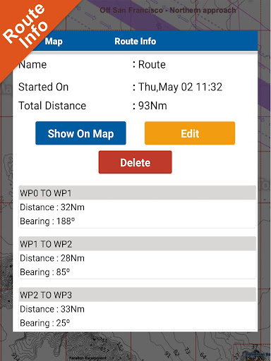
√ Route with unlimited waypoints
√ With Head Up and Course Up feature
√ Geocompass
√ Navigate and see your GPS position on the map
√ Heading Vector Towards the direction movement
√ Distance Measurement Tool to easily calculate the distance from one location to another
√ Insert the target/destination and see in real time your speed, distance and bearing
√ background mode - Flytomap works in background as well, you can swap with another app and receive/make calls send sms while panning and zooming.
√ Unlimited Tracks share via email, visible on Google, Flytomap Viewer, KMZ format - Store your track without the need of cellular data or mobile signal
√ KMZ KML from / to GPX Converter
√ Optimized battery usage
√ ActiveCaptain
• View and contribute to the best boaters community available in the world
• Continuous update of all info (including reviews from the deck) about :
• Marinas
• Anchorages
• Hazards
• Local Knowledge
√ And so much more to come - It’s the only app you will ever need! Our charts are installed on: GARMIN NAVICO LOWRANCE B&G NORTHSTAR EAGLE SIMRAD
Follow us:
▶Twitter @flytomap
▶Web Site flytomap.com
▶Web App viewer.flytomap.com
▶Facebook facebook.com/flytomap
Real time map view of your boat and boats near you, worldwide.
No AIS receiver required, just your mobile!
Various icons depict different vessel categories.
Select any target to see vessel details such as name, MMSI, IMO, call sign, status, speed, heading, coordinates, distance from your GPS location, and more.
Flytomap offers within this app a subscription for a professional GPS chart plotter for only 4.99 USD.
At a glance
Worldwide Marine and Outdoor Maps available when connected, thanks to viewer.flytomap.com
Worldwide Satellite images overlay on charts
Worldwide Terrain features overlay on charts, thanks to Open Street Map, Open Cycle Map, Earth,topo maps by ESRI
NOAA raster charts seamless with continuous updates from the official Government server
ActiveCaptain - Worldwide boaters community * 200.000 + Captains
Use to Explore:
√ The maps are downloaded to the device itself, it works in OFFLINE mode. No need of Internet connection.
√ Latitudes and Longitudes to go to your favorite places
√ Search your Favorite points directly
√ Zoom, Rotate and Pan fast just by a finger touch
√ Route with unlimited waypoints
√ With Head Up and Course Up feature
√ Geocompass
√ Navigate and see your GPS position on the map
√ Heading Vector Towards the direction movement
√ Distance Measurement Tool to easily calculate the distance from one location to another
√ Insert the target/destination and see in real time your speed, distance and bearing
√ background mode - Flytomap works in background as well, you can swap with another app and receive/make calls send sms while panning and zooming.
√ Unlimited Tracks share via email, visible on Google, Flytomap Viewer, KMZ format - Store your track without the need of cellular data or mobile signal
√ KMZ KML from / to GPX Converter
√ Optimized battery usage
√ ActiveCaptain
• View and contribute to the best boaters community available in the world
• Continuous update of all info (including reviews from the deck) about :
• Marinas
• Anchorages
• Hazards
• Local Knowledge
√ And so much more to come - It’s the only app you will ever need! Our charts are installed on: GARMIN NAVICO LOWRANCE B&G NORTHSTAR EAGLE SIMRAD
Follow us:
▶Twitter @flytomap
▶Web Site flytomap.com
▶Web App viewer.flytomap.com
▶Facebook facebook.com/flytomap
{{descriptionMoreText}}
Comments (4)
{{commentText.length}}/{{maxCommentText}}
{{commentError}}{{commentUserError}}
-
{{comment.commentUser.substring(0, 1)}}By {{comment.commentUser}}{{comment.commentDateString}}
-
JBy Johan JohanjohanAug 4,2022
-
jBy jumanzah smdAug 3,2022
-
MBy Marthin SipotaJul 22,2022
-
CBy Cristalliu MireiJul 8,2022
Developer apps
Category Top
apps
- Google Play
- App Store
4
5
Lifestyle
 Daily Diary:Journal with Lock
 Life360: Find Family & Friends
 Pinterest
 T-Mobile Tuesdays
 Frecuencia
Photography
 Picsart AI Photo Editor, Video
 Amazon Photos
 Time Warp Scan - Face Scanner
 ToonApp: Cartoon Photo Editor
 Pixelup - AI Photo Enhancer


More Apps


