


 Art & Design
 Auto & Vehicles
 Beauty
 Business
 Education
 Entertainment
 Finance
 Food & Drink
 Health & Fitness
 House & Home
 Libraries & Demo
 Lifestyle
 Maps & Navigation
 Medical
 Music & Audio
 Parenting
 Personalization
 Photography
 Productivity
 Shopping
 Social
 Sports
 Tools
Tools Travel & Local
 Video Players
 Weather
 Family


 EasyTrails GPS Lite
OS :
Version :11.2
Size :32.77Mb
Updated :Jun 21,2022
Developer :Zirak s.r.l.
 Ask AI
You can ask
the AI some questions about the app
Here are three topics that users may discuss about the EasyTrails GPS Lite app, turned into questions:
1. Is the app's trail mapping feature accurate and reliable for tracking outdoor adventures?
2. Are the app's tracking features easy to use and navigate, even for novice hikers?
3. Does the app provide enough battery life to support extended use on a hike or outdoor excursion?
 Ask AI
Pros and Cons from users' feedback
Based on the user reviews, here are three pros and three cons of the EasyTrails GPS Lite app:
**Pros:**
1. Accurate GPS tracking with clear visuals for easy navigation.
2. Simple and intuitive interface for users of all skill levels.
3. Free version offers many features, making it a great starting point.
**Cons:**
1. Limited offline maps and reliance on cell signal for navigation.
2. Advertisements disrupt the user experience and clutter the screen.
3. Lack of street view and terrain mapping features compared to full version.
App
Downloads
<
>

App
Survey
-
What exercise apps have you heard of or used?
-
Does the frequency of application notifications affect the experience?
-
What is the exercise you generally like to do?
-
The reasons why you choose to exercise are
Description
EasyTrails GPS LITE is the LITE version of EasyTrails GPS, the complete GPS tracker app for your iPhone.
The perfect application for those who are passionate about OUTDOOR ACTIVITIES and TRAVELING, everybody who likes outdoor sports, and not only.
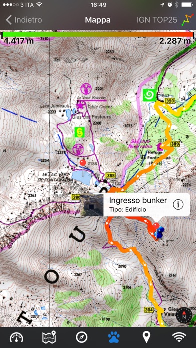
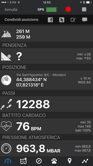
Are you going for a bike or motorcycle ride? Well, EasyTrails GPS will tell you how many miles you traveled, how much time you spent, how high you climbed and many other details. In real-time it will show you the course on a map, comparing it with downloaded tracks and points of interest.
You can import or share all tracks and waypoints, photos and ideas for new journeys with your friends.
Share where you are on Facebook and Twitter through your GPS position, and export your tracks in standard formats, so you can review them on Google Earth, SportTracks and TrailsRunner. Or simply upload them to online services like Garmin Connect, or many others.
It's possible to import tracks by e-mail or Safari (EasyTrails can handle GPX, KML/KMZ and ZIP file formats), or by wi-fi networks, using an improved and easy to use web-based sharing feature.
With the FULL version, you can also calculate routes and let EasyTrails guide you using the new navigation capabilities. You can also let it guide you through previously recorded tracks.
Additionally, EasyTrails GPS can communicate with navigators like Maps, Google Maps, TomTom or Waze (if installed) for more advanced guidance needs.
Load custom cartography, EasyTrails supports KMZ and MBTILES formats.
► For more info, visit our website: www.easytrailsgps.com
NEW FEATURES:
► Heart rate monitoring (paid)
We added the ability to connect to compatible Bluetooth heart rate monitors (such as Polar H6 and H7 devices). Heart rate can be seen in real time from the dashboard.
With the 'Heart rate monitoring' in-app purchase:
- heart rate data will be associated to GPS tracks
- saved tracks will have an extra heart rate chart
- heart rate data will be saved to HealthKit
Additionally, with the 'Colored tracks' in-app purchase, it will be possible to highlight heart rate data directly on the map screen of a recorded track.
OTHER FEATURES:
- Support for many different map types
- Support for different coordinate systems
- Support for user-loaded offline cartography (KMZ and MBTILES)
- Export tracks (single or multiple) in standard formats (GPX, KML/KMZ and CSV), with their associated waypoints and pictures
- Import tracks (GPX and KML/KMZ)
- Import waypoints (GPX and KML/KMZ)
- Resume recording of tracks
- Save waypoints with photos and descriptions
- Navigate to a point of interest
- Sharing via Facebook and Twitter
- Follow a path/track
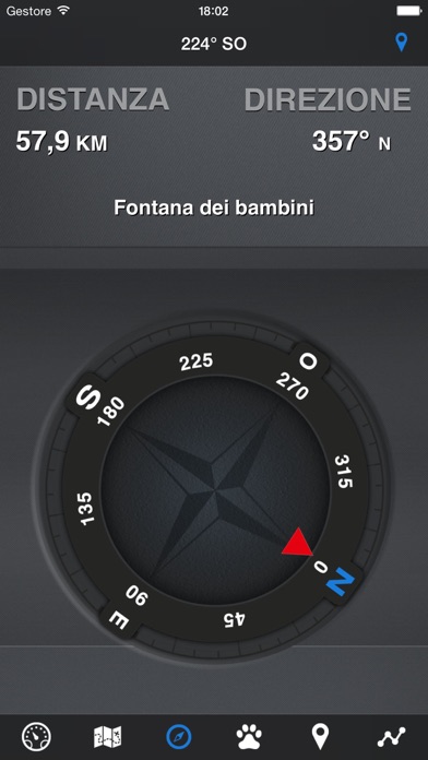
- Navigate (distance / direction) towards any waypoint
- Navigate (distance / direction) towards any track marker (start / pause / resume / end points)
- Advanced Navigation to a waypoint using any navigation app you may have installed
- Upload tracks to GPSies (http://www.gpsies.com)
- Upload tracks to SportTracks (http://sporttracks.mobi)
- Upload tracks to OpenTrail (http://www.opentrail.us)
- Upload tracks to OkMap (http://www.okmap.org)
- Real-time visualization of distance, speed, altitude bearing and other data
- Map Visualization in different modes: street map, satellite, hybrid, terrain
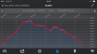
- Charts (elevation profiles, ...)
- Digital Compass
- Heart rate monitoring
- Turn by turn directions
- High battery duration (record in standby)
- Select between metric, imperial and nautical measuring systems
- Intuitive and User Friendly interface
- Lightweight, reliable and accurate
- Doesn't require internet connection
Terms of Use: https://www.apple.com/legal/internet-services/itunes/dev/stdeula/
Privacy Policy: http://www.easytrailsgps.com/wp-content/uploads/2016/05/EasyTrails-GPS-Privacy-Policy.pdf
{{descriptionMoreText}}
Comments (0)
{{commentText.length}}/{{maxCommentText}}
{{commentError}}{{commentUserError}}
-
{{comment.commentUser.substring(0, 1)}}By {{comment.commentUser}}{{comment.commentDateString}}
Category Top
apps
- Google Play
- App Store


More Apps


