


 Art & Design
 Auto & Vehicles
 Beauty
 Business
 Education
 Entertainment
 Finance
 Food & Drink
 Health & Fitness
 House & Home
 Libraries & Demo
 Lifestyle
 Maps & Navigation
 Medical
 Music & Audio
 Parenting
 Personalization
 Photography
 Productivity
 Shopping
 Social
 Sports
 Tools
Tools Travel & Local
 Video Players
 Weather
 Family


OS :
Version :4.8.2
Size :60.29Mb
Updated :Oct 22,2022
Developer :Mapnitude Company Limited
 Ask AI
You can ask
the AI some questions about the app
Here are three topics that users may discuss about the Elevation Altimeter Map app, turned into questions for you:
1. How does the app's GPS accuracy compare to other altimeter apps on the market?
2. Are the topographic maps provided by the app detailed enough for serious hikers and climbers?
3. Does the app's elevation tracking feature work well in areas with poor cellular reception?
 Ask AI
Pros and Cons from users' feedback
I'd be happy to help you with that! After analyzing the user reviews on the Apple App Store, here are three pros and three cons of the Elevation Altimeter Map app:
2Easy to use: Reviewers find the app's interface intuitive and user-friendly, making it simple to navigate and access features.
3Comprehensive maps: Users appreciate the app's detailed topographic maps, which provide valuable information for outdoor enthusiasts.
2Inaccurate GPS: A few reviewers report experiencing issues with the app's GPS
Pros:
1Accurate readings: Users praise the app's ability to provide precise elevation readings, even in areas with poor GPS signal.2Easy to use: Reviewers find the app's interface intuitive and user-friendly, making it simple to navigate and access features.
3Comprehensive maps: Users appreciate the app's detailed topographic maps, which provide valuable information for outdoor enthusiasts.
Cons:
1Limited offline access: Some users complain that the app requires a constant internet connection, making it unusable in areas with poor connectivity.2Inaccurate GPS: A few reviewers report experiencing issues with the app's GPS
I'd be happy to help you with that! After analyzing the user reviews on the Apple App Store, here are three pros and three cons of the Elevation Altimeter Map app:
Pros:
1. Accurate readings: Users praise the app's ability to provide precise elevation readings, even in areas with poor GPS signal.
2. Easy to use: Reviewers find the app's interface intuitive and user-friendly, making it simple to navigate and access features.
3. Comprehensive maps: Users appreciate the app's detailed topographic maps, which provide valuable information for outdoor enthusiasts.
Cons:
1. Limited offline access: Some users complain that the app requires a constant internet connection, making it unusable in areas with poor connectivity.
2. Inaccurate GPS: A few reviewers report experiencing issues with the app's GPS
App
Downloads
>


App
Survey
- Application interactivity Does it affect the experience?
- Does the frequency of application notifications affect the experience?
- Do you prefer more comprehensive software
- Does the update frequency of the application affect the experience?
Description
Find your current elevation, altitude, and height above sea level easily with this altimeter/barometer app.
## Elevation Finder ##
This app helps you observe the elevations of all locations on the surface of the earth by simply touch and move the map around, or input the address/location name. You can also find the elevation of your current location by using online database, built-in GPS, or barometer on your device.
Elevation data benefits flood prevention, prediction of water levels in rivers, lakes, and seas, etc. Thus, knowing the elevation of places is very crucial if you are looking for a flood-free house, or planning for a hiking trip, and more.
## Could-based Altitude Data ##
The easiest way to find altitude of any location on earth. By simply point on the screen, you can get the elevation data from a coordinate location point. “Range Mode” is available for altitude comparison (by graph and line) of each point between two selected locations.
## GPS Altitude Data ##
Use built-in GPS on your device to determine the altitude of your current location. The altitude data of the area you walked-through will be recorded and displayed as a multicolored line on the map. The colors presented on the line indicate different heights. Precision indicators (horizontal resolution and vertical resolution) are displayed on the screen.
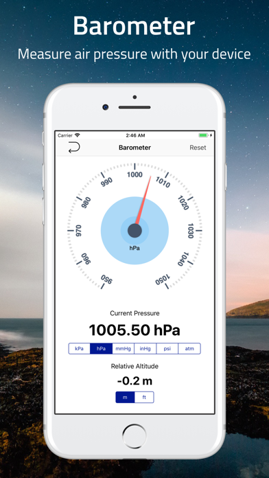
## Barometric Altitude Data ##
Use built-in barometer on your device to determine the elevation of your current location. You can either measure the elevation from raw barometric data, or relative pressure from sea-level. Like GPS data, the result is displayed as a multicolored line.
To get the most accurate data, it is recommended to adjust the sea level pressure and temperature prior to the measurement, and set the offset or calibration value if necessary.
## Standalone Barometer ##
You can use this app as a standalone barometer.
## Air Pressure / Altitude Calculator ##
Atmospheric pressure and/or altitude at your current location are calculated from known altitude, pressure of the location, temperature and/or sea level pressure.
## Support of Coordinate Formats ##
This app not only displays regular latitude and longitude data, but also supports many coordinate systems such as, Universal Transverse Mercator (UTM) coordinate system and Military Grid Reference System (MGRS) and more.
## Export of Data ##
From this app, you can export many useful information including timestamp, altitude, pressure, and coordinates.
Subscription
-------------
Elevation - Sea Level Map is completely free to use with all features. You can subscribe to this application to remove ads and reduce data retrieving delay by 50%.
Device subscriptions are available in these plan and will renew automatically each month, six months or year, unless cancelled.
(Per month) - $4.49
(Per six-months) - $25.99
(Per year) - $48.99
Pricing shown is for the United States store. Pricing in other stores will vary.
Payment for subscriptions will be charged to your iTunes Account at confirmation of purchase
Account will be charged for renewal within 24-hours prior to the end of the current period. Subscription automatically renews unless auto-renew is turned off at least 24-hours before the end of the current period
Subscriptions may be managed by going to your iTunes Account Settings after purchase or by clicking the “Purchase / Manage Subscription. Auto-renewal may be turned off by going to Account Settings after purchase.
Subscription cannot be cancelled during the active subscription period
More information: https://mapnitude.com/elevation
Privacy policy: https://mapnitude.com/privacy-policy
Terms of use: https://mapnitude.com/terms-of-service
Comments (4)
0/255
- LBy Leina :DMar 6,2022
- iBy iAlecksMay 23,2019
- SBy Sy JamesAug 16,2018
- cBy cyberbikerNov 9,2018
- <
- 1
- >
Developer apps
 GeoLogger - Trip Tracker
 #Nowplaying - Tweet Your Music
 ราคาน้ำมัน - ThaiOilPrice
 ราคาทอง - ThaiGoldPrice
 BarcodeEasy
 DistanceCalculator - Map tool
 SunMap - Sun/Moon Toolkit
 DistancePinner
 AddressFinder - Zipcode Lookup
 Area & Distance - Map Measure
 InspireMe - Word Generator
 BlastSim
 Distance - Find My Distance
 Coordinates - GPS Formatter
Category Top
apps
- Google Play
- App Store


More Apps


