


 Art & Design
 Auto & Vehicles
 Beauty
 Business
 Education
 Entertainment
 Finance
 Food & Drink
 Health & Fitness
 House & Home
 Libraries & Demo
 Maps & Navigation
 Medical
 Music & Audio
 Parenting
 Personalization
 Photography
 Productivity
 Shopping
 Social
 Sports
 Tools
Tools Travel & Local
 Video Players
 Weather
 Family


 FATMAP: Ski, Hike, Bike
OS :

Version :3.24.27/3.24.27
Size :/72.70Mb
Updated :Nov 25,2022
Oct 28,2022
Oct 28,2022
Developer :FATMAP - Terrascope Ltd
 Ask AI
You can ask
the AI some questions about the app
Based on online discussions about the Fatmap app, here are three topics and corresponding questions:
1. Navigation and Routing
What are your expectations from the app's navigation features, and how do they compare to other apps?
2. Map and Cartography
How do you think the app's maps and cartography will improve your rides, and what features are you most looking forward to?
3. Community and Sharing
How will you use the app's social features to plan and share your rides, and what kind of content do you want to share with others?
 Ask AI
Pros and Cons from users' feedback
Based on the users' reviews, here are three cons and pros:
**Cons:**
1. Poor offline mapping experience, frequently loses GPS signal and becomes unresponsive.
2. Limited features for freemium users, constant nagging to upgrade to premium.
3. Buggy interface, frequent crashing and slow loading of maps and points of interest.
**Pros:**
1. Accurate and up-to-date maps, covering extensive routes and trail networks globally.
2. Intuitive navigation, clear directions, and elevation profiles for smooth rides.
3. Community-driven, allowing users to report trail conditions, add photos, and share routes.
<
>


App
Survey
-
How much time do you spend on app applications every day?
-
Do you think the stability of the application affects the experience?
-
Application technology innovation Does it affect the experience?
-
Whether the application ad recommendation affects the experience?
Description
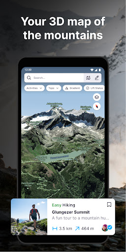
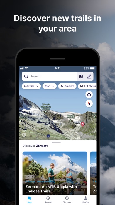
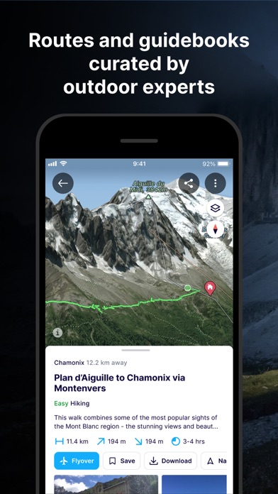
FATMAP is the #1 app for mountain sports.
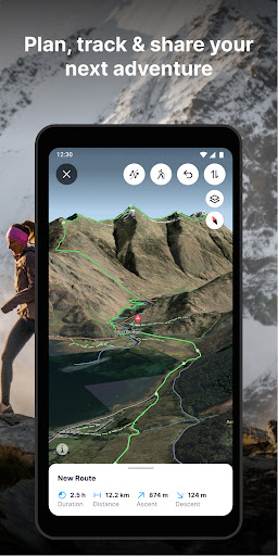
Explore the mountains with confidence with the world's most advanced 3D outdoor map. Plan the perfect route, orientate and navigate along the way, record your day and share it with the community.
Whether hiking, biking, trail running, skiing, ski touring or freeriding, if you love mountain adventures, you'll find your community on FATMAP.
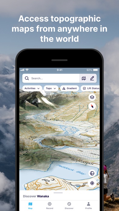
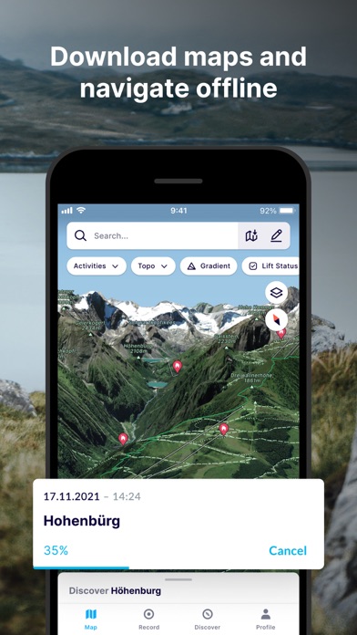
- Global 3D outdoor map with real-time information and offline maps
- Mountain biking, trail running, hiking, resort and backcountry skiing maps
- Stunning satellite terrain imagery, in summer and winter
- Record and re-live all your adventures in 3D
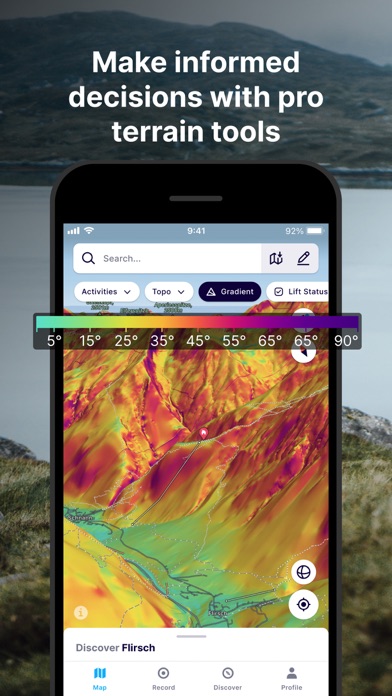
- Advanced terrain analysis tools including slope, elevation, avalanche and more
- Follow people to see their latest adventures
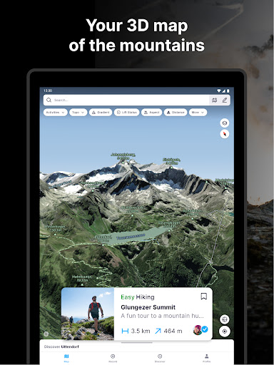
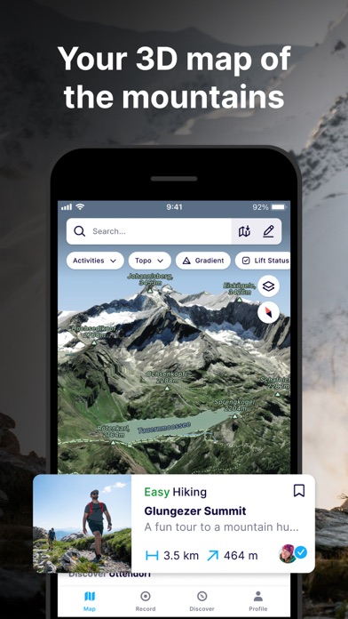
GLOBAL MAP FOR THE OUTDOORS
- Know the area like a local and plan your route in detail with the most advanced 3D outdoor map that helps you intuitively understand the terrain
- Find any outdoor trail: footpaths, hiking trails, singletrack and more
- Discover outdoor points of interest like mountain huts and campsites
- Choose between summer or winter/snow map imagery (where available)
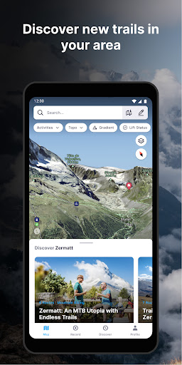
FIND YOUR NEXT MOUNTAIN ADVENTURE
- Search and find the right route for you or be inspired by the community
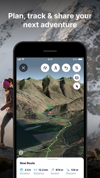
PLAN & NAVIGATE
- Create and share custom locations / waypoints
- Locate yourself on the map at any time
- Use peak names, roads, footpaths, rivers and heaps of other map data to quickly orientate yourself and navigate to your next objective
- Navigate trails while riding, hiking, running or skiing
UNDERSTAND THE TERRAIN LIKE AN EXPERT
- Understand the terrain like never before to make better decisions with Gradient, Avalanche, Flats, Aspect and more layers.
RE-LIVE YOUR ADVENTURE IN 3D
- Track your adventure in the app or connect with Suunto, Garmin or Strava to see your tracks in 3D
- Share amazing fly-throughs of your adventure
GO FURTHER WITH FATMAP EXPLORE
FATMAP Explore is for everyone who wants more out of their outdoor experiences.
TOPO MAP LAYERS
- Use the Global Topo map or see official topo maps from swisstopo, USGS, IGN, basemap.it and more in 3D
REAL-TIME SNOW CONDITIONS
- See current snow depth, fresh snow, and snow forecast directly on the map.
REAL-TIME RESORT STATUS
- See which lifts and pistes/runs are open or closed in real time. (At supported Ski Resorts)
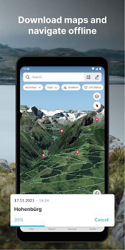
OFFLINE MAPS
- Download any part of the map and use it without an internet connection.
- Conserve battery by using the app in airplane mode
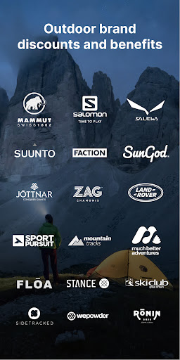
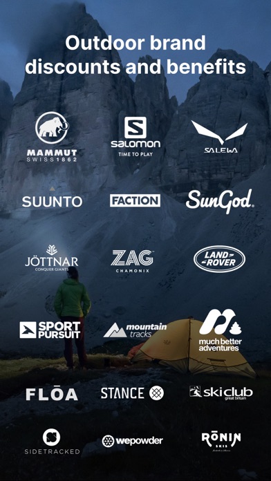
THE BEST DEALS ON OUTDOOR GEAR
- Explore members receive discounts in major partner brands like Mammut, Salomon, Suunto, Faction Skis and many more.
(Access to FATMAP Explore requires a paid membership.)
- REVIEWS -
“FATMAP has changed the way I see and act in the mountains” - Xavier De Le Rue, The North Face Athlete
“Useful and inspiring (and also looks really really cool.)” - Forbes
"[FATMAP] may be the most ambitious adventure tech to hit the market since sat phones" - Outside Online
“An app that will revolutionise your backcountry freeriding experience” - Red Bull
** For technical support, contact: [email protected]
Terms of Service: https://about.fatmap.com/terms
Privacy Policy: https://about.fatmap.com/privacy
Explore the mountains with confidence with the world's most advanced 3D outdoor map. Plan the perfect route, orientate and navigate along the way, record your day and share it with the community.
Whether hiking, biking, trail running, skiing, ski touring or freeriding, if you love mountain adventures, you'll find your community on FATMAP.
- Global 3D outdoor map with real-time information and offline maps
- Mountain biking, trail running, hiking, resort and backcountry skiing maps
- Stunning satellite terrain imagery, in summer and winter
- Record and re-live all your adventures in 3D
- Advanced terrain analysis tools including slope, elevation, avalanche and more
- Follow people to see their latest adventures
GLOBAL MAP FOR THE OUTDOORS
- Know the area like a local and plan your route in detail with the most advanced 3D outdoor map that helps you intuitively understand the terrain
- Find any outdoor trail: footpaths, hiking trails, singletrack and more
- Discover outdoor points of interest like mountain huts and campsites
- Choose between summer or winter/snow map imagery (where available)
FIND YOUR NEXT MOUNTAIN ADVENTURE
- Search and find the right route for you or be inspired by the community
PLAN & NAVIGATE
- Create and share custom locations / waypoints
- Locate yourself on the map at any time
- Use peak names, roads, footpaths, rivers and heaps of other map data to quickly orientate yourself and navigate to your next objective
- Navigate trails while riding, hiking, running or skiing
UNDERSTAND THE TERRAIN LIKE AN EXPERT
- Understand the terrain like never before to make better decisions with Gradient, Avalanche, Flats, Aspect and more layers.
RE-LIVE YOUR ADVENTURE IN 3D
- Track your adventure in the app or connect with Suunto, Garmin or Strava to see your tracks in 3D
- Share amazing fly-throughs of your adventure
GO FURTHER WITH FATMAP EXPLORE
FATMAP Explore is for everyone who wants more out of their outdoor experiences.
TOPO MAP LAYERS
- Use the Global Topo map or see official topo maps from swisstopo, USGS, IGN, basemap.it and more in 3D
REAL-TIME SNOW CONDITIONS
- See current snow depth, fresh snow, and snow forecast directly on the map.
REAL-TIME RESORT STATUS
- See which lifts and pistes/runs are open or closed in real time. (At supported Ski Resorts)
OFFLINE MAPS
- Download any part of the map and use it without an internet connection.
- Conserve battery by using the app in airplane mode
THE BEST DEALS ON OUTDOOR GEAR
- Explore members receive discounts in major partner brands like Mammut, Salomon, Suunto, Faction Skis and many more.
(Access to FATMAP Explore requires a paid membership.)
- REVIEWS -
“FATMAP has changed the way I see and act in the mountains” - Xavier De Le Rue, The North Face Athlete
“Useful and inspiring (and also looks really really cool.)” - Forbes
"[FATMAP] may be the most ambitious adventure tech to hit the market since sat phones" - Outside Online
“An app that will revolutionise your backcountry freeriding experience” - Red Bull
** For technical support, contact: [email protected]
Terms of Service: https://about.fatmap.com/terms
Privacy Policy: https://about.fatmap.com/privacy
{{descriptionMoreText}}
Comments (5)
{{commentText.length}}/{{maxCommentText}}
{{commentError}}{{commentUserError}}
-
{{comment.commentUser.substring(0, 1)}}By {{comment.commentUser}}{{comment.commentDateString}}
-
LBy Lucas 'Fehu' FREDERICHAug 14,2022
-
PBy P MoyzAug 10,2022
-
NBy Nicolas FavroJul 29,2022
-
SBy Stéphane ROUXJul 24,2022
-
TBy Tony MorelJul 22,2022
Category Top
apps
- Google Play
- App Store
4
5
Lifestyle
 Daily Diary:Journal with Lock
 Life360: Find Family & Friends
 Pinterest
 T-Mobile Tuesdays
 Frecuencia
Photography
 Picsart AI Photo Editor, Video
 Amazon Photos
 Time Warp Scan - Face Scanner
 ToonApp: Cartoon Photo Editor
 Pixelup - AI Photo Enhancer


More Apps


