


 Art & Design
 Auto & Vehicles
 Beauty
 Business
 Education
 Entertainment
 Finance
 Food & Drink
 Health & Fitness
 House & Home
 Libraries & Demo
 Lifestyle
 Maps & Navigation
 Medical
 Music & Audio
 Parenting
 Personalization
 Photography
 Productivity
 Shopping
 Social
 Sports
 Tools
Tools Travel & Local
 Video Players
 Weather
 Family


 GPS Area Measurement Lite
OS :
Version :2.0
Size :3.39Mb
Updated :Apr 13,2020
Developer :Oceanic Software
 Ask AI
You can ask
the AI some questions about the app
Based on online discussions about the app "GPS Area Measurement Lite", here are three topics and corresponding questions for you:
**Topic 1: Measurement Accuracy**
Is the app's area calculation accurate enough for most users?
**Topic 2: Difficulty Level**
Is the app's interface intuitive and easy to navigate for beginners?
**Topic 3: GPS Integration**
Does the app require a stable GPS signal to provide accurate measurements?
 Ask AI
Pros and Cons from users' feedback
I'd be happy to help you with that! After analyzing the user reviews on the Apple App Store, here are three pros and three cons of the GPS Area Measurement Lite app:
Pros:
1. Accurate measurements: Users praise the app's ability to provide accurate measurements of areas, making it a reliable tool for various purposes.
2. Easy to use: Many reviewers find the app's interface intuitive and easy to navigate, even for those who are not tech-savvy.
3. Free version available: The app offers a free version with limited features, allowing users to try it out before deciding whether to upgrade to the paid version.
Cons:
1. Limited features in free version: Some users feel that the free version is too limited, lacking features that are available in the paid version.
2. Ads can be
App
Downloads
<
>


App
Survey
-
Do you think the stability of the application affects the experience?
-
Does the frequency of application notifications affect the experience?
-
What is your Mobile System?
-
Can your phone delete the useless apps that come with your phone?
Description
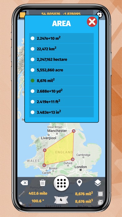
!!! High accurate area calculations. Please verify with other area tools !!!
!!! Developed for professional business use !!!
!!! Support for 50 languages !!!
Youtube Video Link : https://youtu.be/yFiAkRbmIoo
"GPS Area Measure" is an excellent application for the calculation of the area on the map. App gives the highly accurate area, distance, angle and volume information.
Easy and fast insertion point can coordinate with the very delicate.
GPS Area Measure is used for:
- Map Measure
- Outdoor Measure
- Sports
- Road repairing
- Range finder
- Concrete
- Roofing
- Underground
- Paving
- Fence
- Distance measure
- Seal coating
- Run
- Walk
- Bike
- Jog tracking
- Field and pasture area measure
- Garden and farm work and planning
- Construction
- Agricultural measure
- Solar panel installation
- Roof area estimation
- Trip planning
Key Features:
- Support for 50 languages
- GPS Tracking support
- Distance, Angle and Area Modes
- Metric and Imperial units
- Distance between points
- Angle between lines
- Area calculation
- Address information
- Volume calculation
- Direction info for lines (N/NNE/NE/ENE/E/ESE/SE/SSE/S/SSW/SW/WSW/W/WNW/NW/NNW)
- GPS coordinates for selected point
- Manage saved KML files (Open, Save and Share)
- Export KML file format to Maps
- Terrain and Satellite Views
- Delete last point or all points
Supported Languages:
- English
- Deutsch
- Français
- Italiano
- Português
- Español
- Dansk
- Nederlands
- Hrvatski
- Svenska
- Polski
- Latvijas
- Lietuvos
- Magyar
- Norsk
- Suomi
- Български
- Český
- na hÉireann
- Ελληνικά
- Român
- Pусский
- עברית
- Cрпски
- Slovenčina
- Kiswahili
- ภาษาไทย
- Telugu
- Türkçe
- Український
- اردو
- Việt
- Afrikaanse taal
- 中国人
- Kannada
- Català
- 한국의
- العربية
- Shqiptar
- Azerice
- Беларускія
- Bengali
- 中国的
- Indonesia
- Armenian
- فارسی
- Galicia
- Georgian
- Indian
Meet afstand dop Landbou قياس المسافة، في منطقة الزاوية ذات حجم اراضي للخرائط، تتبع القطاع الزراعي السقوف والزراعة،Masa Zona Largësia Terreni Harta Kulmi Bujqësia Neurria angelua Tomo mapa Teilatu Nekazaritza Вымярэнне Адлегласць Фарм Сельская гаспадарка Мярка Отстояния Обем Farm покрив Селско стопанствоOpatření vzdálenost střechy ZemědělstvíLandbrug Ukur Jarak Peta Pelacakan Atap Mezuri Areo Distanco Volumo Tereno Mapo kameraoj Tegmento Agrikulturo Meede ala Distants köide Maastiku Kaart jälgimise Katuse Põllumajandus Meet afstand hoek Dak Landbouw Anggulo Dami Lupain Agrikultura Mittaa Matka Maasto seuranta Katto Maatalous Mesure Plan de suivi de la ferme toit Mesurau Ardal o Bell Tir Olrhain To Amaeth Medida Ángulo o terreo Rastreamento Tellado Agricultura Mezi Zòn Distans Ang Volim Teren do kay Agrikilti Mjera Udaljenost Praćenje Farma Krov Beart Limistéar Fad Uillinn Imleabhar Tír raon Rianú an bhFeirm Díon Talmhaíochta Medida Distancia Techo Mät Distans Vinkel Volym Karta Tak Jordbruk Misura distanza angolo tetto Agricoltura Mál Fjarlægð Horn Rekja Landbúnaður Mesura Distància Sostre Agricultura 측정 지역 거리 앵글 볼륨 지형 지도 추적 농장 지붕 농업 Mensura Longius Angulus Agri sequi villarum culmina Rolnictwo Pasākums zona leņķa sējums Karte izsekošana jumts Priemonė plotas Atstumas kampas tomas Terrain Žemėlapis sekimas Farm Stogo Žemės ūkisMérés könyv Tető Mezőgazdaság Мерка земјоделство Langkah Kawasan Jarak Volum Penjejakan Farm Bumbung Pertanian Miżura Żona tad Distanzi Angolu Volum Mappa 'Traċċar bjut Agrikoltura Mål Avstand Tak Landbruk Medida Distância Ângulo o Terreno Rastreamento Telhado Agricultura Măsura Zona distante unghi volum Harta agricole Измерение Расстояние Фарм Сельское хозяйство Мјера Ареа дужина Угао Волуме Терраин Мап праћење Фарма Кровни Opatrenia vzdialenosť strechy Ukrep prostor dolžina zvezek sledenje Kipimo Umbali Mandhari Ramani paa Kilimo Вимірювання Відстань Фарм Сільське господарство Đo lường xa Khối lượng địa hình Theo dõi Nông nghiệp מאָס שטח ווייַטקייט אַנגלע באנד טערראַין מאפע טראַקינג פאַרם דאַך אַגריקולטורע
{{descriptionMoreText}}
Comments (0)
{{commentText.length}}/{{maxCommentText}}
{{commentError}}{{commentUserError}}
-
{{comment.commentUser.substring(0, 1)}}By {{comment.commentUser}}{{comment.commentDateString}}
Category Top
apps
- Google Play
- App Store


More Apps


