


 Art & Design
 Auto & Vehicles
 Beauty
 Business
 Education
 Entertainment
 Finance
 Food & Drink
 Health & Fitness
 House & Home
 Libraries & Demo
 Maps & Navigation
 Medical
 Music & Audio
 Parenting
 Personalization
 Photography
 Productivity
 Shopping
 Social
 Sports
 Tools
Tools Travel & Local
 Video Players
 Weather
 Family


 GPS Waypoints Navigator | MAPS
OS :
Version :9.24
Size :
Updated :Aug 9,2022
Developer :Disciple Skies Software
 Ask AI
You can ask
the AI some questions about the app
Here are three topics that users might discuss about GPS Waypoints Navigator on the internet, turned into questions for you:
1. How does the app's routing algorithm handle incorrect or outdated GPS data?
2. Can I customize the app's interface to better suit my specific navigation needs?
3. Has the app's offline GPS capability been effective for you during signal-poor areas?
 Ask AI
Pros and Cons from users' feedback
Based on the user reviews, here are three cons and three pros, 15 words limited for each item:
**Cons:**
1. Glitchy performance, some users reported app crashing or freezing frequently.
2. Limited customization options, users desire more control over route planning and display.
3. Ads are intrusive, annoying, and sometimes obstructive of navigation screens.
**Pros:**
1. Accurate GPS tracking and turn-by-turn directions, users praise reliable navigation.
2. User-friendly interface, simple to use and understand, even for beginners.
3. Saves frequently used routes, making re-use quick and easy, users appreciate convenience.
Note: These points are based on the majority of user reviews, but individual experiences may vary.
App
Downloads
<
>


App
Survey
-
Why do you uninstall an app?
-
How much traffic the app consumes Does it affect the experience?
-
Ease of use of the application Does it affect the experience?
-
Whether the app response speed affects the experience?
Description
Convert your phone into a powerful GPS supported by beautiful, easy to read maps and find your way around with confidence in the wilderness, at sea or in the city.
GPS Waypoints Navigator offers dozens of options for navigating the back-country, waterways and roadways. Venture beyond network reach using offline maps and tools that only require a good view of the sky. Create and organize waypoints, record trails and share location data with friends.
★ Typical Usage:
✔️ Trail hiking and track recording.
✔️ Off road and ATV (all-terrain vehicle) navigation.
✔️ Maritime navigation.
✔️ Camping / orienteering.
✔️ City and wilderness exploration.
✔️ Geocaching.
✔️ Surveying and coordinate recording.
✔️ Hunting and fishing.
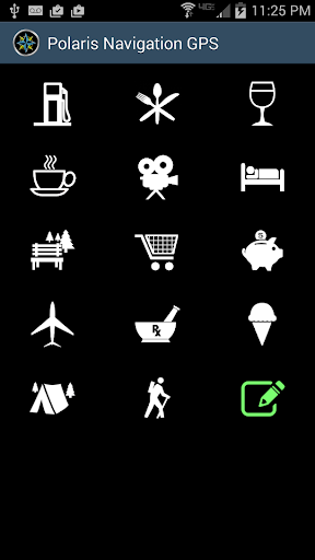
With GPS Waypoints Navigator, you get:
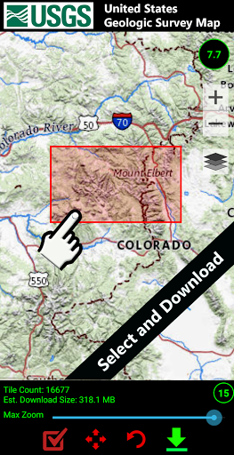
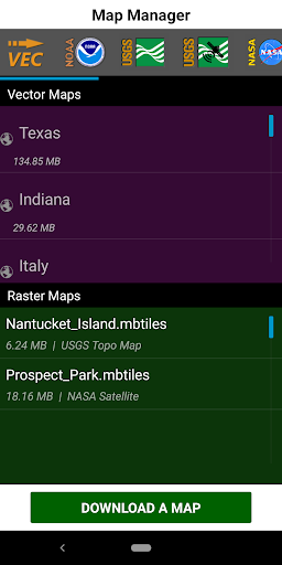
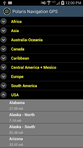
★ Unlimited access to our 3D vector map library with over 400 maps. Download maps for offline use. Maps can be transferred to your SD card to free-up internal memory.
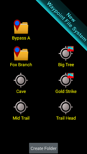
★ Waypoint and trail management systems including our one-of-a-kind waypoint filing system.
★ Waypoint search.
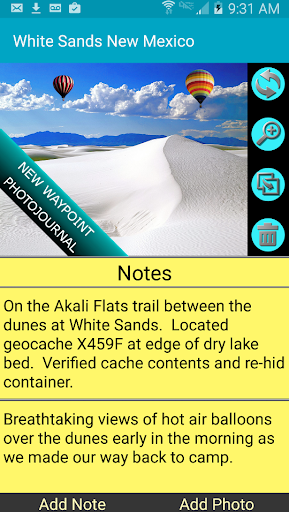
★ Waypoint photojournal - attach notes and coordinate-tagged photos to your waypoints.
★ Maps! Choose from multiple sources: Downloadable vector and raster maps, Topo Maps, Google Maps, Satellite Maps, OpenStreetMaps- MapNik, Cycling Maps, OpenSeaMap, USGS Topo Maps, Canada Toporama, Trail Hiking and Biking, NOAA Nautical Charts (raster and ENC) and several others.
★ KML, GPX and KMZ file importing and exporting for trails, waypoints, photos and notes. Share data and view it in Google Earth.
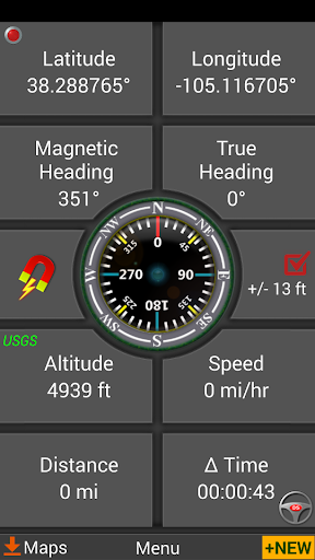
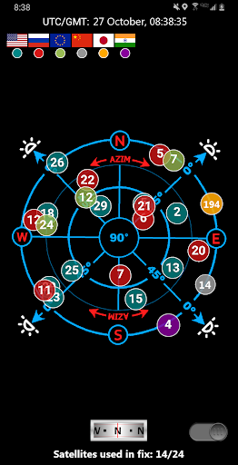
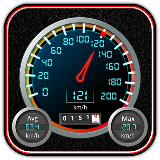
★ A panel for GPS parameters.
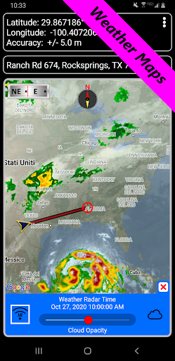
★ Weather Maps with animated live Doppler radar and cloud patterns.
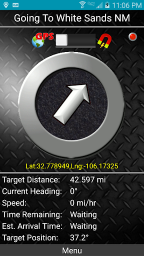
★ Navigational and waypoint compasses.
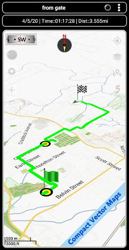
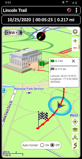
★ Trail recording and trail drawing board.
★ Drag anchor alert. Drop anchor and set a drift radius.
★ Military coordinate finder.
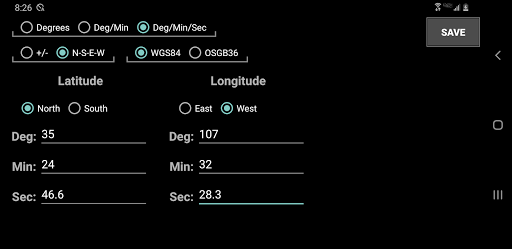
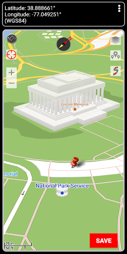
★ Several waypoint creation tools: Enter coordinates, drop a pin on a map, save your current position or enter an address.
★ Two Waypoint Guidance Systems including a dynamic waypoint compass that always points to your target and GPS Reflected Pseudo-Radar.
★ Map Search: Supports entry of addresses and coordinates in just about any format including UTM, MGRS.
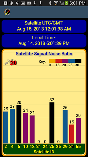
★ GPS Satellite graphs and position charts.
★ Email a map of your position.
★ Seamless integration with Google Earth.
★ Marine Navigation. Features NOAA Nautical Charts, OpenSeaMap and nautical unit reporting.
★ Supports several coordinate formats: Latitude/Longitude as degrees, deg:min or deg:min:sec, UTM, MGRS, British Ordnance Survey.
★ Waypoint proximity alerts.
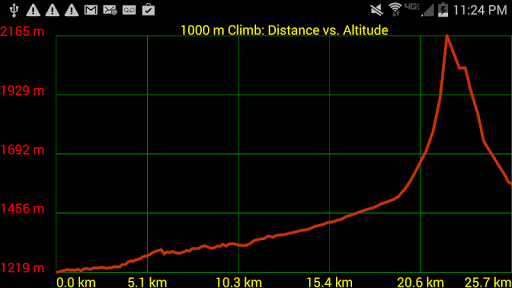
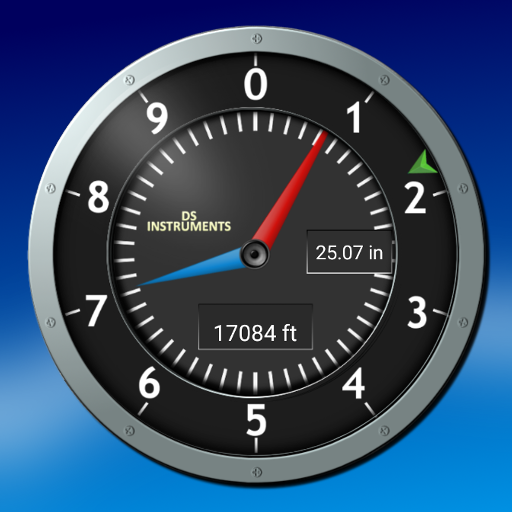
★ Altitude profiles for trails and altitude lookup for any waypoint.
★ Maps with several measurement tools allow you to get distance and bearing to any point and inter-waypoint distances.
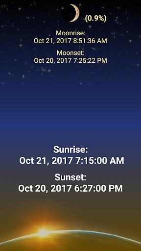
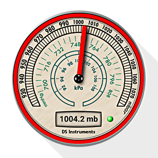
★ Stay abreast of environmental conditions that may affect navigation with weather maps and reporting for sunrise, sunset, moonrise, moonset, moon phase- also useful for planning expedition turn around time or time to make camp.
With GPS Waypoints Navigator, everything is included in your original purchase. No account setup or registration is required.
Also get:
- Turn-by-turn driving directions and driving maps via a digital connection to the Google Maps app on your device.
- Control settings for all compasses. Use magnetic control for indoors, underground or in caves, use GPS otherwise.
- Export your tracks and waypoints as GPX files and upload them to Openstreetmap to help build / update the map.
- Import GPX files from Garmin.
- Altitude sourcing: Choose satellite, US Geologic Survey location based altitude or SRTM data. USGS available only in contiguous U.S.A, Canada and Mexico.
- Excellent customer service.
- Supports multiple languages: English, Spanish, German, Portuguese, Japanese, French, Italian, Russian, Chinese (traditional and simplified).
With GPS Waypoints Navigator, every navigation experience will be as easy as a walk in the park!
GPS Waypoints Navigator offers dozens of options for navigating the back-country, waterways and roadways. Venture beyond network reach using offline maps and tools that only require a good view of the sky. Create and organize waypoints, record trails and share location data with friends.
★ Typical Usage:
✔️ Trail hiking and track recording.
✔️ Off road and ATV (all-terrain vehicle) navigation.
✔️ Maritime navigation.
✔️ Camping / orienteering.
✔️ City and wilderness exploration.
✔️ Geocaching.
✔️ Surveying and coordinate recording.
✔️ Hunting and fishing.
With GPS Waypoints Navigator, you get:
★ Unlimited access to our 3D vector map library with over 400 maps. Download maps for offline use. Maps can be transferred to your SD card to free-up internal memory.
★ Waypoint and trail management systems including our one-of-a-kind waypoint filing system.
★ Waypoint search.
★ Waypoint photojournal - attach notes and coordinate-tagged photos to your waypoints.
★ Maps! Choose from multiple sources: Downloadable vector and raster maps, Topo Maps, Google Maps, Satellite Maps, OpenStreetMaps- MapNik, Cycling Maps, OpenSeaMap, USGS Topo Maps, Canada Toporama, Trail Hiking and Biking, NOAA Nautical Charts (raster and ENC) and several others.
★ KML, GPX and KMZ file importing and exporting for trails, waypoints, photos and notes. Share data and view it in Google Earth.
★ A panel for GPS parameters.
★ Weather Maps with animated live Doppler radar and cloud patterns.
★ Navigational and waypoint compasses.
★ Trail recording and trail drawing board.
★ Drag anchor alert. Drop anchor and set a drift radius.
★ Military coordinate finder.
★ Several waypoint creation tools: Enter coordinates, drop a pin on a map, save your current position or enter an address.
★ Two Waypoint Guidance Systems including a dynamic waypoint compass that always points to your target and GPS Reflected Pseudo-Radar.
★ Map Search: Supports entry of addresses and coordinates in just about any format including UTM, MGRS.
★ GPS Satellite graphs and position charts.
★ Email a map of your position.
★ Seamless integration with Google Earth.
★ Marine Navigation. Features NOAA Nautical Charts, OpenSeaMap and nautical unit reporting.
★ Supports several coordinate formats: Latitude/Longitude as degrees, deg:min or deg:min:sec, UTM, MGRS, British Ordnance Survey.
★ Waypoint proximity alerts.
★ Altitude profiles for trails and altitude lookup for any waypoint.
★ Maps with several measurement tools allow you to get distance and bearing to any point and inter-waypoint distances.
★ Stay abreast of environmental conditions that may affect navigation with weather maps and reporting for sunrise, sunset, moonrise, moonset, moon phase- also useful for planning expedition turn around time or time to make camp.
With GPS Waypoints Navigator, everything is included in your original purchase. No account setup or registration is required.
Also get:
- Turn-by-turn driving directions and driving maps via a digital connection to the Google Maps app on your device.
- Control settings for all compasses. Use magnetic control for indoors, underground or in caves, use GPS otherwise.
- Export your tracks and waypoints as GPX files and upload them to Openstreetmap to help build / update the map.
- Import GPX files from Garmin.
- Altitude sourcing: Choose satellite, US Geologic Survey location based altitude or SRTM data. USGS available only in contiguous U.S.A, Canada and Mexico.
- Excellent customer service.
- Supports multiple languages: English, Spanish, German, Portuguese, Japanese, French, Italian, Russian, Chinese (traditional and simplified).
With GPS Waypoints Navigator, every navigation experience will be as easy as a walk in the park!
{{descriptionMoreText}}
Comments (5)
{{commentText.length}}/{{maxCommentText}}
{{commentError}}{{commentUserError}}
-
{{comment.commentUser.substring(0, 1)}}By {{comment.commentUser}}{{comment.commentDateString}}
-
sBy syamsul ersadMay 27,2020
-
PBy Pengguna GoogleDec 4,2018
-
PBy Pengguna GoogleJul 4,2018
-
PBy Pengguna GoogleDec 31,2017
-
PBy Pengguna GoogleMay 4,2017


Category Top
apps
- Google Play
- App Store
4
5
Lifestyle
 Daily Diary:Journal with Lock
 Life360: Find Family & Friends
 Pinterest
 T-Mobile Tuesdays
 Frecuencia
Photography
 Picsart AI Photo Editor, Video
 Amazon Photos
 Time Warp Scan - Face Scanner
 ToonApp: Cartoon Photo Editor
 Pixelup - AI Photo Enhancer


More Apps


