


 Art & Design
 Auto & Vehicles
 Beauty
 Business
 Education
 Entertainment
 Finance
 Food & Drink
 Health & Fitness
 House & Home
 Libraries & Demo
 Lifestyle
 Maps & Navigation
 Medical
 Music & Audio
 Parenting
 Personalization
 Photography
 Productivity
 Shopping
 Social
 Sports
 Tools
Tools Travel & Local
 Video Players
 Weather
 Family


 GPS-Tracker Pro
OS :
Version :1.8
Size :1.92Mb
Updated :Apr 2,2017
Developer :Marvin Wagner
 Ask AI
 Ask AI
Pros and Cons from users' feedback
I'd be happy to help you with that! After analyzing the user reviews on the Apple App Store, here are three pros and three cons of the GPS Tracker Pro app:
Pros:
1. Accurate location tracking: Users praise the app's ability to provide precise location updates, making it easy to keep tabs on loved ones.
2. User-friendly interface: Reviewers appreciate the app's simple and intuitive design, making it easy to navigate and use.
3. Real-time updates: Users appreciate the app's ability to provide real-time updates on location, allowing for timely responses and peace of mind.
Cons:
1. Battery drain: Some users report that the app can drain their device's battery quickly, especially when used extensively.
2. Limited customization options: Reviewers mention that the app lacks customization options, making it
App
Downloads
<
>


App
Survey
-
Where do you get the new APP
-
What is the number of APPs on your phone?
-
Does the update frequency of the application affect the experience?
-
How much time do you spend on app applications every day?
Description
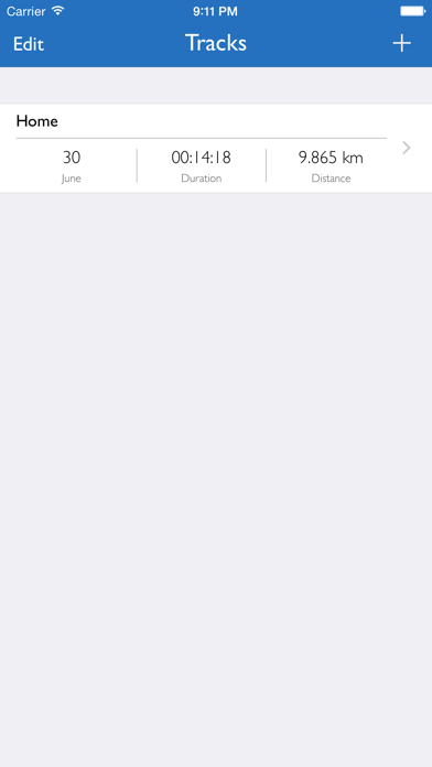
Turn your iDevice with the GPS Tracker Pro in one of the advanced GPS tracker.
Whether you hike, bicycle, motorcycle or driving a car or even fly, record your activities and watch them at a later date to at rest.
Once you have started the recording, you can track your route live on the map. The recording can be paused at any time and continued at a later date. It is not recorded only your current location, but also additionally your current speed and altitude.
During and after recording you always following values are in the index are available:
- Put up
- Duration
- Number of recorded locations
- Average speed
- Maximum speed
- Average height
- Lowest height
- Highest level
Create additionally markers on the map to save interesting places that you want to remember.
Furthermore, you are free to choose whether the route should be one or more colors (shown on the map The color depends on your speed, choose between a static scale (0 km / h -.. 50 km / h -100 km / h ) and a dynamic scale (depending on your speed).
To get a better view of a recording, you can, for example, Send to your iPad.
The following settings can at any time, even during a recording, be adjusted individually:
- Notification of inactivity
- Notification of poor reception
- Interval of a status report
- GPS accuracy Desired
- Removing filter
- Map type
- View the current position on the map
- Display of the starting point
- Display of the end point
- Display of marks
- Use of a background path
- Use of a multi-colored path
- Use of a dynamic scale
Share. Your recordings with your friends via AirDrop, by email or iMessage The following formats are available for export:
- GPS Tracker Pro
- KML
- GPX
- CSV
NOTE: If you do not have GPS enabled device and still want to start recording, then you need an additional GPS receiver. When you watch the recordings no GPS receiver is required.
WARNING: Continued use of GPS running in the background can dramatically decrease battery life.
{{descriptionMoreText}}
Comments (5)
{{commentText.length}}/{{maxCommentText}}
{{commentError}}{{commentUserError}}
-
{{comment.commentUser.substring(0, 1)}}By {{comment.commentUser}}{{comment.commentDateString}}
-
eBy embosiFeb 8,2019
-
FBy Flyingboat SvenMay 3,2022
-
RBy Ranny99Sep 16,2017
-
jBy jaybdayDec 23,2020
-
MBy MarconipaintFeb 16,2020
Category Top
apps
- Google Play
- App Store


More Apps


