


 Art & Design
 Auto & Vehicles
 Beauty
 Business
 Education
 Entertainment
 Finance
 Food & Drink
 Health & Fitness
 House & Home
 Libraries & Demo
 Lifestyle
 Maps & Navigation
 Medical
 Music & Audio
 Parenting
 Personalization
 Photography
 Productivity
 Shopping
 Social
 Sports
 Tools
Tools Travel & Local
 Video Players
 Weather
 Family


 Hurricane Track- Storm Tracker
OS :
Version :3.3.3
Size :21.83Mb
Updated :Dec 31,2020
Developer :Mach Software Design
 Ask AI
You can ask
the AI some questions about the app
Here are three topics that users may discuss about the Hurricane Track app, turned into questions:
1. What features do you think are most useful for tracking hurricanes and storms with this app?
2. How do you plan to use the app's storm surge and flood risk warnings to stay safe during a hurricane?
3. Are you looking forward to receiving push notifications from the app to stay informed about severe weather events?
 Ask AI
Pros and Cons from users' feedback
I'd be happy to help you with that! After analyzing the user reviews on the Apple App Store, here are three pros and three cons of the Hurricane Track Storm Tracker app:
Pros:
1. Accurate tracking: Users praise the app's ability to provide accurate and timely updates on hurricane tracks and storm systems.
2. Easy to use: Reviewers find the app's interface intuitive and easy to navigate, making it simple to track storms and receive alerts.
3. Reliable notifications: Users appreciate the app's reliable push notifications, which keep them informed of storm updates and changes.
Cons:
1. Limited international coverage: Some users note that the app's focus on US storms means it lacks coverage for international weather events.
2. Outdated design: A few reviewers criticize the app's outdated design, which they find clutter
App
Downloads
<
>
App
Survey
-
Does the feedback of the application affect the experience?
-
Do you group them together?
-
Do you think the stability of the application affects the experience?
-
What is your Mobile System?
Description
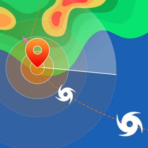
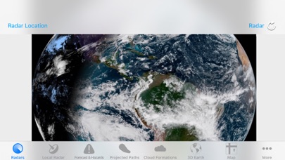
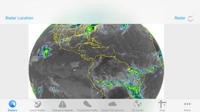
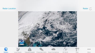
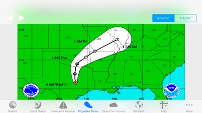
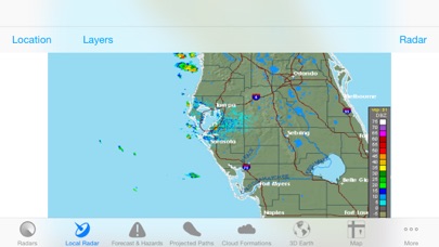
Hurricane Track 3.0 is the most advanced, modern, and easiest to use Hurricane Tracking and Radar application! Hurricane Track 3.0 features incredible new features such as 18 World Radars featuring the newly launched GOES-16 Satellite, a new customizable dynamic Local Radar using NEXRAD "next-generation radar" technology, Forecast and Hazard warnings, future projected tropical cyclone paths, Lightning Intensity Radars, Sea Temperatures, Cloud Formations that can potentially turn into tropical cyclones, Maps, an interactive 3D Earth, detailed tropical storm information and discussion, and much much more! Hurricane Track 3.0 brings the most advanced hurricane tracking technology to your fingertips, and the best part is Hurricane Track is Free!
Innovative Features!
- 300+ World Radars: 18 Radar Locations around the globe with 17 Radars per Location
- Customizable Advanced Local Radar using NEXRAD technology (U.S. only)
- Projected Tropical Storm paths: Future tropical storm paths for the next five days
- Forecast and Hazards give you detailed forecasts for different periods of the day, and hazards that you should look out for (Tornado Watch, Flood Warning, High Tide, etc.) (U.S. only, Updated hourly)
- Innovative Lightning Intensity Radars
- Interactive Map with Tropical Cyclones, Live Clouds, and Earthquakes
- Sea Surface Temperatures for the past two months
- Graphical outlines of cloud formations that can turn into potential Tropical Storms
- 3D Earth with Live Clouds, Tropical Storms, and Earthquakes
- Tropical Storm and Weather Information, Summaries, Discussions, and Outlooks
8 World Radars for 12 different Locations around the Globe!
- Visible - Unenhanced visible imagery that transitions to IR2 overnight
- Shortwave - Channel 2 Shortwave Infrared imagery - Shortwave, sometimes considered "night visible"
- Water Vapor - IR Channel 3
- Aviation - Aviation color enhancement
- Dvorak - Used for tropical classifications with the Dvorak technique
- JSL - Used to bring out low level and high level clouds in tropical cyclones
- Funktop - Higlights intense areas of precipitation
- Rainbow - Rainbow enhancement curve, colorful enhancement
{{descriptionMoreText}}
Comments (3)
{{commentText.length}}/{{maxCommentText}}
{{commentError}}{{commentUserError}}
-
{{comment.commentUser.substring(0, 1)}}By {{comment.commentUser}}{{comment.commentDateString}}
-
BBy Black and Gold AttackApr 5,2018
-
RBy ReconMarine911Jul 14,2022
-
aBy add whittyMar 12,2022


Category Top
apps
- Google Play
- App Store


More Apps


