


 Art & Design
 Auto & Vehicles
 Beauty
 Business
 Education
 Entertainment
 Finance
 Food & Drink
 Health & Fitness
 House & Home
 Libraries & Demo
 Lifestyle
 Maps & Navigation
 Medical
 Music & Audio
 Parenting
 Personalization
 Photography
 Productivity
 Shopping
 Social
 Sports
 Tools
Tools Travel & Local
 Video Players
 Weather
 Family


 Public transport map Paris
OS :
Version :3.18
Size :121.66Mb
Updated :May 8,2022
Developer :Khrystyna Skliarova
 Ask AI
You can ask
the AI some questions about the app
Here are three topics that users might discuss about the app, turned into questions for you:
1. How does the app help with navigating public transport in Paris?
2. Are the map and route information accurate and up-to-date?
3. Can the app be used offline or is internet connection required?
 Ask AI
Pros and Cons from users' feedback
Based on the user reviews of the app "Public Transport Map Paris", I've extracted the following conclusions:
**Pros:**
1. "Easy to navigate and plan journeys, great for tourists and locals alike."
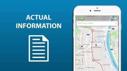
2. "Maps are accurate and up-to-date, making it a reliable transportation guide."
3. "Well-designed interface and user-friendly, perfect for on-the-go travel planning."
**Cons:**
1. "Some routes and schedules lack details, causing confusion for new users."
2. "Occasional loading issues and slow performance hinder app usability."
3. "Limited language support, making it difficult for non-French speakers to use."
App
Downloads
<
>


App
Survey
-
Whether the application ad recommendation affects the experience?
-
Where do you get the new APP
-
Do you think the stability of the application affects the experience?
-
The degree of memory and power consumption Does it affect the experience?
Description
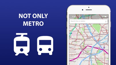
The entire Paris's transport infrastructure of in one app. Metro lines, trams and buses routes, transfer stations - all of those you will find inside.
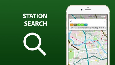
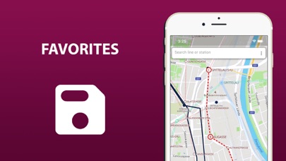
Search by station name or route number, saving chosen routes and geo-positioning are available in the basic version.
Why do this app is should be tried?
1) On the screen of your device you will see the whole Paris's public transport scheme, and the more scale is choosen the more details are given.
2) The map of Paris shows not only metro lines, but tram and bus routes as well. Stations of possible metro-tram-bus transfers are grouped.
3) The search by station name will help you to find it on the map and select the proper transport. Search by route number allows you to quickly determine whether it suitable or not.
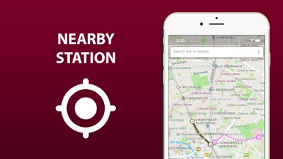
4) By allowing the application to access the location and mark it on the map, you will see stations nearby. So you won't ever get lost and without any help you will be able to get anywhere in the city.
5) The routes you planned in advance, can be saved in the list and you may use them again at any time.
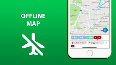
In an extended version, the app allow you:
6) To use all of the above in offline mode without wasting time searching for the wifi reception.
7) To check a short schedule of public transport routes if it is needed.
8) To know not just where the station is, but where the stops of all routes passing through are located as well.
Confident use of all types of public transport is the key to the most comfortable visiting Paris.
{{descriptionMoreText}}
Comments (0)
{{commentText.length}}/{{maxCommentText}}
{{commentError}}{{commentUserError}}
-
{{comment.commentUser.substring(0, 1)}}By {{comment.commentUser}}{{comment.commentDateString}}
Developer apps


Category Top
apps
- Google Play
- App Store


More Apps


