


 Art & Design
 Auto & Vehicles
 Beauty
 Business
 Education
 Entertainment
 Finance
 Food & Drink
 Health & Fitness
 House & Home
 Libraries & Demo
 Lifestyle
 Maps & Navigation
 Medical
 Music & Audio
 Parenting
 Personalization
 Photography
 Productivity
 Shopping
 Social
 Sports
 Tools
Tools Travel & Local
 Video Players
 Weather
 Family


 SityTrail hiking trail GPS
OS :
Version :VARY
Size :
Updated :Sep 8,2022
Developer :Geolives Belgium S.P.R.L.
 Ask AI
You can ask
the AI some questions about the app
Here are three potential topics that users may discuss about the Geolives app, turned into questions for you:
1. How do you find the accuracy of the Geolives app in tracking directions and locations in your daily life?
2. Have you experienced any issues with connection speed or data usage when using the Geolives app on your device?
3. What do you think about the features and interface of the Geolives app -- do they improve your navigation and exploration experiences?
 Ask AI
App
Downloads
<
>


App
Survey
-
Application interactivity Does it affect the experience?
-
Do you think the payment of application features affects the experience?
-
Does the frequency of application notifications affect the experience?
-
How much time do you spend on app applications every day?
Description
Go and discover all the paths around the world
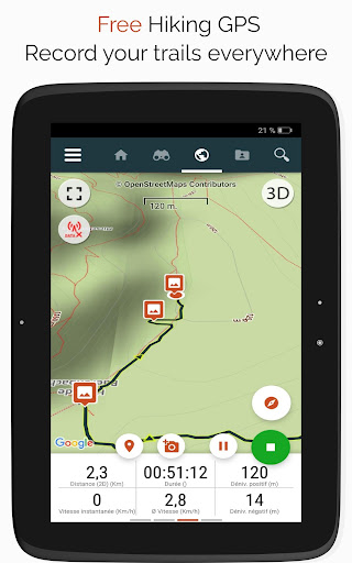
• Record your trails while taking HD and geo-tagged pictures of your adventures.
• Travelled distance, Km-effort, average speed, calories burned, etc.
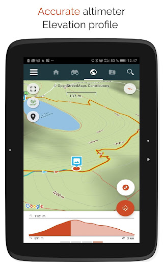
• Accurate altimeter, height differences computing and elevation profile displaying your current location.
• Alarm when you go off the path of the trail being followed. No more need to backtrack!
• Automatic triggering of points of interest with text-to-speech.
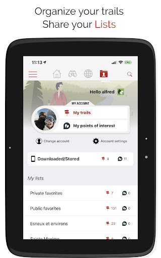
• Create a free account and all your data will be available everywhere on every device.
• Easy creation of trails and points of interest from our website.
• With our online editor, create your own trails using a Web browser on your PC/Mac and then access them directly from your smartphone to experience them on the ground.
• Sort and classify your trails and points of interest in your own lists.
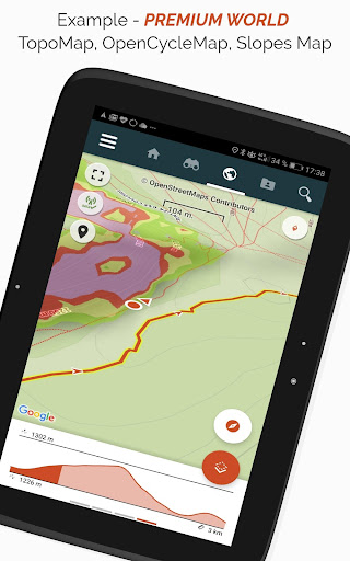
Go further and become a PREMIUM user!
• Download world topographic maps for offline use.
• Discover GR hiking paths, European hiking routes, Santiago de Compostela routes for pilgrims, etc.
• Add topographic maps of your choice, from IGN France, IGN / NGI Belgium, IGN Spain, swisstopo, Austria, USA (USGS topographic mapping), Canada (Toporama).
• You can also discover all cycling networks: Greenway network in France, Ravel in Belgium, European cycling routes, knot points networks in Flanders and the Netherlands.
• And in winter, discover all the ski slopes with their names.
• Access the public catalogue of trails from SityTrail members and communities.
• Advanced tracking and guiding features with calculation of the remaining distance and time and vocal instructions at intersections.
• Go further and transform your favourite trails into real multimedia guides with text, photos, video links, and share them with the SityTrail community.
• Create your own hiker communities and manage your members and newsfeeds.
• Create trails with our advanced features for trail editing via our website.
• Print trails in PDF format with QR codes. (A4, A3).
• Access geotagged Wikipedia articles from our SityTrip module.
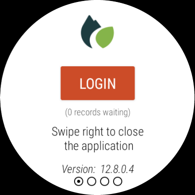
Record a trail on your Wear OS watch
You can record a trail on your Wear OS watch in standalone mode (not connected to an Android smartphone) or in paired mode (connected to an Android smartphone).
The application also allows logging in to your existing SityTrail account (from the screen which is the most on the left) when the watch is used in standalone mode.
Important Information
• Some features need an internet connection.
• The prolonged use of GPS can reduce battery levels.
• Record your trails while taking HD and geo-tagged pictures of your adventures.
• Travelled distance, Km-effort, average speed, calories burned, etc.
• Accurate altimeter, height differences computing and elevation profile displaying your current location.
• Alarm when you go off the path of the trail being followed. No more need to backtrack!
• Automatic triggering of points of interest with text-to-speech.
• Create a free account and all your data will be available everywhere on every device.
• Easy creation of trails and points of interest from our website.
• With our online editor, create your own trails using a Web browser on your PC/Mac and then access them directly from your smartphone to experience them on the ground.
• Sort and classify your trails and points of interest in your own lists.
Go further and become a PREMIUM user!
• Download world topographic maps for offline use.
• Discover GR hiking paths, European hiking routes, Santiago de Compostela routes for pilgrims, etc.
• Add topographic maps of your choice, from IGN France, IGN / NGI Belgium, IGN Spain, swisstopo, Austria, USA (USGS topographic mapping), Canada (Toporama).
• You can also discover all cycling networks: Greenway network in France, Ravel in Belgium, European cycling routes, knot points networks in Flanders and the Netherlands.
• And in winter, discover all the ski slopes with their names.
• Access the public catalogue of trails from SityTrail members and communities.
• Advanced tracking and guiding features with calculation of the remaining distance and time and vocal instructions at intersections.
• Go further and transform your favourite trails into real multimedia guides with text, photos, video links, and share them with the SityTrail community.
• Create your own hiker communities and manage your members and newsfeeds.
• Create trails with our advanced features for trail editing via our website.
• Print trails in PDF format with QR codes. (A4, A3).
• Access geotagged Wikipedia articles from our SityTrip module.
Record a trail on your Wear OS watch
You can record a trail on your Wear OS watch in standalone mode (not connected to an Android smartphone) or in paired mode (connected to an Android smartphone).
The application also allows logging in to your existing SityTrail account (from the screen which is the most on the left) when the watch is used in standalone mode.
Important Information
• Some features need an internet connection.
• The prolonged use of GPS can reduce battery levels.
{{descriptionMoreText}}
Comments (4)
{{commentText.length}}/{{maxCommentText}}
{{commentError}}{{commentUserError}}
-
{{comment.commentUser.substring(0, 1)}}By {{comment.commentUser}}{{comment.commentDateString}}
-
rBy roger itieAug 17,2022
-
JBy Jul OfenAug 16,2022
-
NBy Nicolas BierwertsAug 12,2022
-
EBy Eric BottinAug 11,2022
Developer apps


Category Top
apps
- Google Play
- App Store


More Apps


