


 Art & Design
 Auto & Vehicles
 Beauty
 Business
 Education
 Entertainment
 Finance
 Food & Drink
 Health & Fitness
 House & Home
 Libraries & Demo
 Lifestyle
 Maps & Navigation
 Medical
 Music & Audio
 Parenting
 Personalization
 Photography
 Productivity
 Shopping
 Social
 Sports
 Tools
Tools Travel & Local
 Video Players
 Weather
 Family


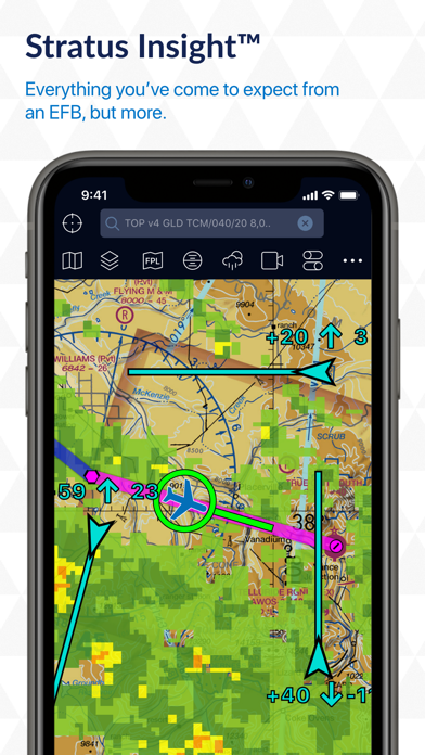
 Stratus Insight EFB
OS :
Version :5.20
Size :228.30Mb
Updated :Jul 22,2022
Developer :Aerovie, LLC
 Ask AI
You can ask
the AI some questions about the app
Based on Stratus Insight EFB's reviews and ratings, here are three topics that users commonly discuss online:
1. "What are the most useful features of Stratus Insight EFB for flight planning and navigation?"
2. "How does Stratus Insight EFB improve pilot situational awareness and reduce workload?"
3. "What are the biggest advantages and limitations of using Stratus Insight EFB versus other flight planning apps?"
 Ask AI
Pros and Cons from users' feedback
After analyzing the reviews of the Stratus Insight EFB app, here are three cons and pros:
**Cons:**
1. "Crashes frequently, disrupting important flight operations and causing frustration."
2. " Limited features and functionality, failing to meet users' expectations."
3. "Poor user interface, leading to confusion and difficulty navigating the app."
**Pros:**
1. "User-friendly design, making it easy to access vital flight information anytime."
2. "Impressive graphics, providing clear and detailed visual representations of flight plans."
3. "Reliable and accurate weather forecasting, helping pilots make informed decisions."
Let me know if you'd like me to help with anything else!
App
Downloads
<
>


App
Survey
-
Why do you uninstall an app?
-
The degree of memory and power consumption Does it affect the experience?
-
Ease of use of the application Does it affect the experience?
-
What is your Mobile System?
Description
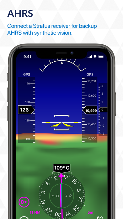
Stratus Insight is a full electronic flight bag (EFB) suite for pilots that includes AHRS with synthetic vision, TAWS, VFR sectional maps, IFR low/high charts, and geo-referenced approach plates.
More than an EFB, Stratus Insight also offers:
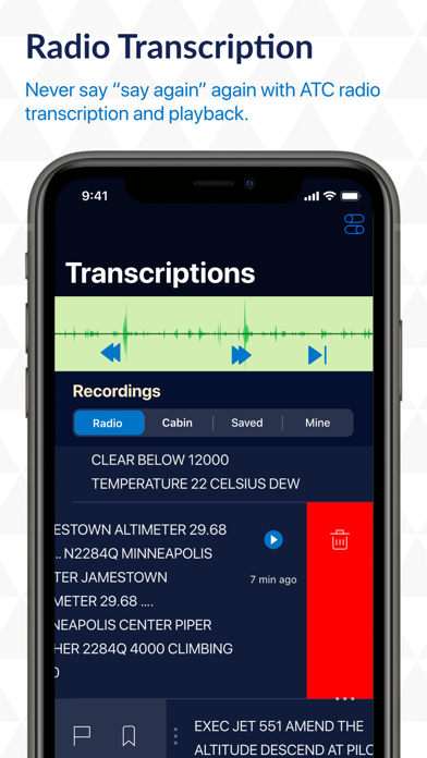
Radio Transcription & Playback
Stratus Insight boasts a custom-built speech recognition system inside the app. When paired with a Stratus Audio Cable, the ATC Radio Transcription feature works similar to visual voicemail. ATC communications are converted into text, providing a helpful visual assist for referencing previous audio clips. This enables pilots to receive a clearance, ATIS, or other important ATC communications without needing to write them down
Vertical Weather Profile
The Vertical Weather Profile previews your route in the vertical slice from departure to destination, up to eight days out, so you can see the conditions you’ll encounter based on your departure time, aircraft speed, and each intermediate airport.
Smart Flight Plan
If a TFR or changes in weather force you to take an alternate route, the Smart Flight Plan tool considers things like fuel stops and day/night currency.
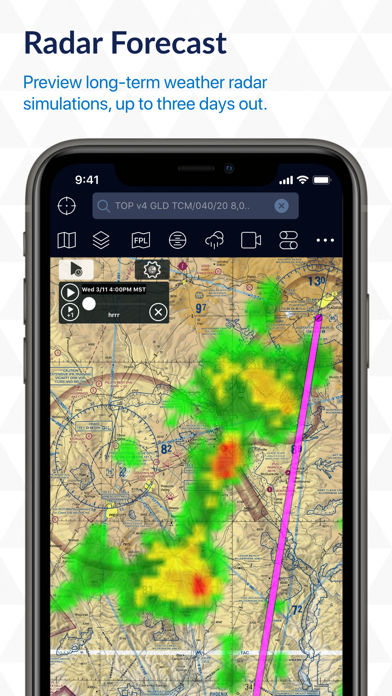
Radar Forecast
Radar Forecast provides long-term weather radar simulations up to three days out, and you can fast forward your weather radar in one-hour increments.
Stratus Audio Cable
The Stratus Audio Cable (available to purchase for $49.99 from the Appareo web store) is needed to enable the radio transcription and playback feature.
Seamless Integration with Stratus
The app supports all generations of Stratus receivers, and the user experience is seamless. Stratus receivers provide WAAS GPS, AHRS, in-flight weather, and ADS-B traffic.
Apple Watch
Uses HealthKit to detect hypoxia-like symptoms for pilot health monitoring including nearby airport weather watch faces and weather radar on watch.
{{descriptionMoreText}}
Comments (4)
{{commentText.length}}/{{maxCommentText}}
{{commentError}}{{commentUserError}}
-
{{comment.commentUser.substring(0, 1)}}By {{comment.commentUser}}{{comment.commentDateString}}
-
aBy aJ alaskaApr 29,2018
-
LBy Lara Croft 180Jan 24,2019
-
FBy Flier97Oct 26,2017
-
mBy mikevioJul 31,2018
Category Top
apps
- Google Play
- App Store


More Apps


