


 Art & Design
 Auto & Vehicles
 Beauty
 Business
 Education
 Entertainment
 Finance
 Food & Drink
 Health & Fitness
 House & Home
 Libraries & Demo
 Lifestyle
 Maps & Navigation
 Medical
 Music & Audio
 Parenting
 Personalization
 Photography
 Productivity
 Shopping
 Social
 Sports
 Tools
Tools Travel & Local
 Video Players
 Weather
 Family


 Weather Alert Map USA
OS :
Version :2.4
Size :68.18Mb
Updated :Jan 22,2022
Developer :Elecont LLC
 Ask AI
You can ask
the AI some questions about the app
Here are three topics that users might discuss about the Weather Alert Map USA app, turned into questions:
1. What features do you like most about the app's severe weather alerts and notifications?
2. How do you find the accuracy of the app's forecast and weather radar mapping compared to other sources?
3. Have you ever received a false alarm or incorrect warning from the app, and how did you handle it?
 Ask AI
Pros and Cons from users' feedback
Based on the users' reviews, here are three pros and three cons of the Weather Alert Map USA app:
**Pros:**
1. Accurate and timely weather updates help users prepare for severe weather conditions.
2. Easy-to-use interface provides clear and concise information about weather alerts and warnings.
3. Push notifications keep users informed of changing weather conditions and potential hazards.
**Cons:**
1. Some users experience app crashes and freezing issues, causing frustration and inconvenience.
2. Limited customization options for users to tailor the app to their specific needs.
3. Inconsistent performance on older devices, leading to slow loading times and glitches.
App
Downloads
<
>
App
Survey
-
Do you think the aesthetics of the interface UI affects the experience?
-
Whether the app response speed affects the experience?
-
How much traffic the app consumes Does it affect the experience?
-
Does the frequency of application notifications affect the experience?
Description
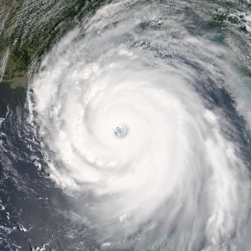
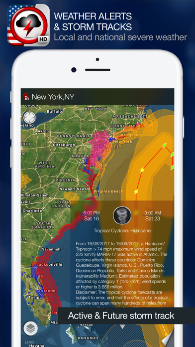
Weather Alert Map is the only app you need for the latest severe weather information. Check LIVE storm track, future path and get critical weather alerts for your location in easy and intuitive way - directly on the map.
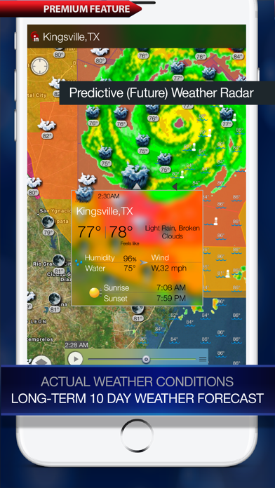
App offers High-resolution, predictive (future) weather radar, Satellite images of national and local cloud cover, current weather conditions, 10-day and hourly weather forecasts, Lightning tracker, Sea surface temperature, Tide predictions, Air quality and Earthquakes via In-App purchase. Stay ahead of severe weather wherever you are with the Weather Alert Map application!
With Alert Map you will see all watches, warnings, and advisories issued by the National Weather Service. They cover just about anything you can think of including, air quality, avalanches, blizzards, floods, earthquakes, high winds, hurricanes, thunderstorms and so much more.
You will see these warnings color coded in the affected areas on the map. If you tap on it, you will get a summarized version of the advisory or warning, and you can tap it for more detailed information.
Key Features (Free):
• Interactive vector-based severe weather alerts and details.
• Advisories, watches, and warnings for: Severe Storms, Tornadoes, Wildfires, Earthquakes, Winter Weather, Extreme Temperatures, Tropical Storms, Hurricanes, Typhoons, Volcanoes, Tsunami, Wind, 911 Outages, Fog, Flooding, Civil Emergencies, Nuclear Power Plant Warnings, Law Enforcement Warnings, Local Emergencies, Child Abduction Emergencies, Avalanches, and more.
Radar (IAP):
Displays animated weather radar around your current location, allowing you to quickly see what weather is coming your way.
• Past, current and future weather radar images.
• High resolution radar. Stunning and sharp images.
• Full, animated radar from the NWS for the entire U.S.
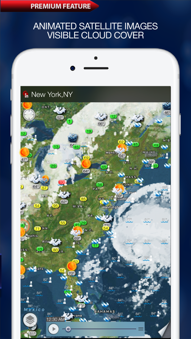
Satellite (IAP):
Satellite images provide an excellent view on the clouds in the sky and an indication of the weather over the North American continent, Europe, Japan, Indonesia and Australia.
• Satellite data comes from GOES, European and Japan satellites
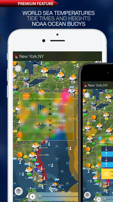
Sea surface temperature (IAP):
Provides useful information for Fisherman, Divers, Surfers, Sailors, Lifeguards, boaters, and anyone that needs to know the water temperatures near them.
• Provides sea surface temperature based on buoys and satellite maps
• Provides zoom and pan functionality
Tide prediction (IAP):
• Times and Heights for high and low tides for thousands of ports, harbors and popular coastal locations around the world.
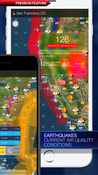
Air Quality (IAP):
The Air Quality Index (AQI) is a forecast, updated hourly, of what the 24 hour average AQI will be for the current day.
• Provides air quality data for the U.S, includes levels for fine particles, ozone and etc.
Weather (IAP):
Allows you to easily pan and zoom so you can get unmatched detail of weather in your neighborhood or half a world away.
• Provides current weather conditions and a weather forecast up to 10 days ahead for cities all over the world.
• Current weather conditions and temperatures on top of the interactive maps
• Long-term 10-day weather forecast, hourly forecast
Earthquakes (IAP):
Provides near realtime updates of the latest earthquakes across U.S., Worldwide.
• Generates a real-time map of earthquakes that have occurred over the past day in the world. The map includes the the strength of any earthquake with a magnitude over 1.0.
• Uses data from multiple agencies worldwide, including the USGS, and the EMSC.
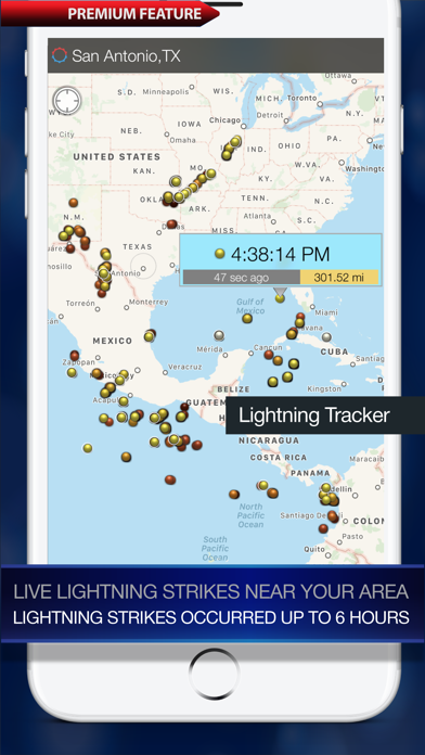
Lightning Tracker (IAP):
• Live lightning strikes near your area
• Lightning strikes occurred up to 6 hours
{{descriptionMoreText}}
Comments (2)
{{commentText.length}}/{{maxCommentText}}
{{commentError}}{{commentUserError}}
-
{{comment.commentUser.substring(0, 1)}}By {{comment.commentUser}}{{comment.commentDateString}}
-
PBy ProMeteorologistNow!!!Jul 18,2015
-
aBy atimberframertooAug 12,2019
Developer apps
 Weather 365 Pro - Long range weather forecast and sea surface temperature
 Rain radar and storm tracker for Japan
 World Weather Map Live
 Cyclone - hurricane tracker
 Weather Travel Map
 Radar MAX Future Weather Radar
 Weather Alert Map Europe
 Weather and wind map
 Weather 365 - Event Planner
 Buoy Finder NOAA NDBC
 Tides PRO - Tide Times
 Radar Sky - NOAA Weather Radar
 Radar HD Future Weather Radar
 Weather Clock Widget
 eWeather HD - Weather & Alerts
 Lightning Tracker
Category Top
apps
- Google Play
- App Store


More Apps


