


 Art & Design
 Auto & Vehicles
 Beauty
 Business
 Education
 Entertainment
 Finance
 Food & Drink
 Health & Fitness
 House & Home
 Libraries & Demo
 Lifestyle
 Maps & Navigation
 Medical
 Music & Audio
 Parenting
 Personalization
 Photography
 Productivity
 Shopping
 Social
 Sports
 Tools
Tools Travel & Local
 Video Players
 Weather
 Family


 Wildfire - Fire Map Info
OS :
Version :1.1.20
Size :11.73Mb
Updated :Dec 7,2021
Developer :LW Brands, LLC
 Ask AI
You can ask
the AI some questions about the app
Here are three potential discussion topics related to the Wildfire App, turning into questions for you to answer:
1. Do you think this app can accurately track and display wildfire locations in real-time?
2. What features do you think the developers should add to increase the app's effectiveness in emergency situations?
3. How do you plan to use this app to stay informed and safe during a potential wildfire emergency?
 Ask AI
Pros and Cons from users' feedback
Based on the users' reviews of the Wildfire Fire Map Info app, here are three pros and cons:
**Pros:**
1. Easy to use with a simple interface, allowing users to quickly access fire info.
2. Reliable and accurate map data helps users stay informed during wildfire events.
3. Excellent for outdoor enthusiasts and emergency responders seeking up-to-date fire information.
**Cons:**
1. Limited functionality, failing to provide detailed information on evacuation routes.
2. App can be slow to load, causing frustration during critical wildfire situations.
3. Lack of real-time updates, leaving users waiting for fresh information.
App
Downloads
<
>
App
Survey
-
Does the frequency of application notifications affect the experience?
-
Whether the app response speed affects the experience?
-
The degree of memory and power consumption Does it affect the experience?
-
What is the number of APPs on your phone?
Description
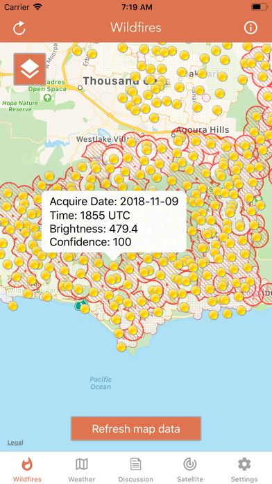
Download the most comprehensive Wildfire app for iOS.
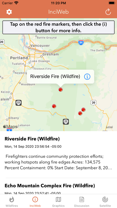
CURRENT WILDFIRES
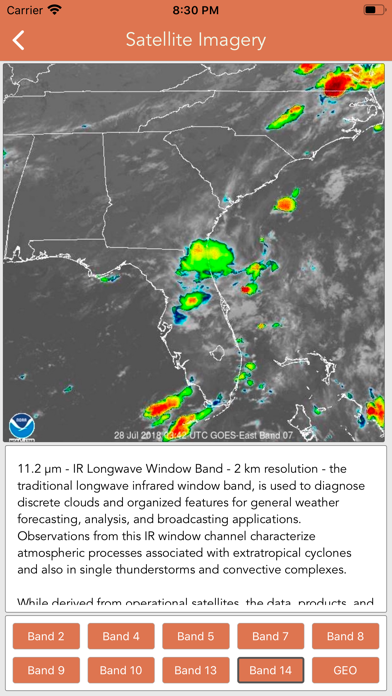
- MODIS Thermal Satellite Fire Detection
- VIIRS IBAND Fire Detection
- MODIS + VIIRS Spot Details
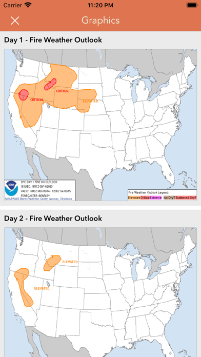
- Fire Weather Outlook: Days 1 - 8
- Large Fire Points
- Dry Thunderstorm Fire Weather Outlook
- National Fire Incident Reports
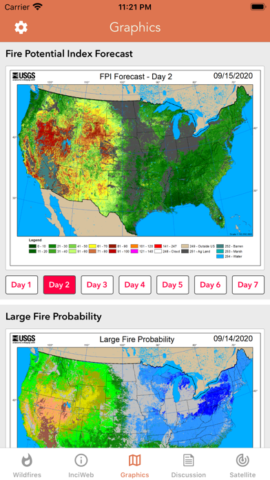
- Fire Potential Index: 7-day Forecast
- Large Fire Probability
- Fire Danger Rating
- Expected Large Fires per PSA
- National Significant Fire Outlook: 4-months
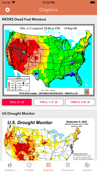
- NFDRS Dead Fuel Moisture
- US Drought Monitor & Index
HAZARDOUS WILDFIRE CONDITION ZONES
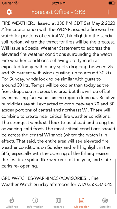
- Detailed NOAA discussion
GOES-16 SATELLITE IMAGERY ANIMATIONS
- Regional zones (CONUS)
* Available for iPhone and iPad with single purchase *
Feel free to contact me at [email protected] if you have any questions.
Enjoy.
{{descriptionMoreText}}
Comments (5)
{{commentText.length}}/{{maxCommentText}}
{{commentError}}{{commentUserError}}
-
{{comment.commentUser.substring(0, 1)}}By {{comment.commentUser}}{{comment.commentDateString}}
-
FBy FireWxJoeMar 11,2020
-
SBy Siikosys1Sep 14,2018
-
wBy writingEachDay()Nov 10,2018
-
DBy DollyGurlJun 17,2020
-
cBy chris_blokeSep 22,2019
Developer apps
 National Hurricane Center Data
 Marine Weather Forecast Pro
 Lake Ontario Boating Weather
 Canada Marine Weather Forecast
 Boating Weather and Tides
 Elk Calls & Hunting Sounds
 New Years Resolutions Tracker
 Fishing Weather Forecast
 Topo Map & Hiking Tracker
 Lake Erie Boating Weather
 Turkey Call App
 Lightning Tracker & Storm Data
 Softball Radar Gun +
 Surf Report and Forecast Tool
 High Tide - Charts and Graphs
 Golf Swing Speed Analyzer
 Florida Boating Weather
 Snowmobile Trails - New York
 Birthday Countdown & Gift List
 River Levels & Flows
 Ocean Water Temperature
 Baseball Radar Gun +
 Coyote Calls & Predator Sounds
 Great Lakes Boating Weather
 Topographic Maps & Trails
 Deer Calls & Hunting Sounds
 CDOT Colorado Road Conditions
 NOAA Marine Forecast & Weather
 Snow Report & Forecast
 Ski Tracker & Snow Forecast
 Wind Speed Forecast App
 Christmas Gift List Tracker
 National Weather Forecast Data
 Aurora Forecast & Alerts
 Nautical Charts & Maps
 Road Conditions - California
Category Top
apps
- Google Play
- App Store


More Apps


