


 Art & Design
 Auto & Vehicles
 Beauty
 Business
 Education
 Entertainment
 Finance
 Food & Drink
 Health & Fitness
 House & Home
 Libraries & Demo
 Lifestyle
 Maps & Navigation
 Medical
 Music & Audio
 Parenting
 Personalization
 Photography
 Productivity
 Shopping
 Social
 Sports
 Tools
Tools Travel & Local
 Video Players
 Weather
 Family


 Caltrans QuickMap
OS :
Version :3.2.9
Size :17.80Mb
Updated :Aug 3,2022
Developer :California Department of Transportation
 Ask AI
You can ask
the AI some questions about the app
Here are three topics that users might discuss about Caltrans QuickMap online:
1. What features does Caltrans QuickMap offer for route planning and traffic monitoring?
2. How does Caltrans QuickMap help you avoid traffic congestion and find alternative routes?
3. What kind of data does Caltrans QuickMap provide for real-time traffic updates and road closures?
Let me know if you'd like me to help with anything else!
 Ask AI
Pros and Cons from users' feedback
Based on the users' reviews, here are three pros and three cons of the Caltrans QuickMap app:
**Pros:**
1. "Easy to navigate and get real-time traffic updates, helping me plan my commute."
2. "Accurate directions and clear map displays make it a valuable tool for daily driving."
3. "Intuitive interface and regular updates make it a reliable resource for road information."
**Cons:**
1. "Sometimes app freezes or crashes, making it frustrating to use when needed most."
2. " Limited features and lack of customization options leave room for improvement."
3. " No option to report incidents or provide feedback to Caltrans team, disappointingly."
App
Downloads
<
>


App
Survey
-
Whether the app response speed affects the experience?
-
Ease of use of the application Does it affect the experience?
-
Application interactivity Does it affect the experience?
-
Where do you get the new APP
Description
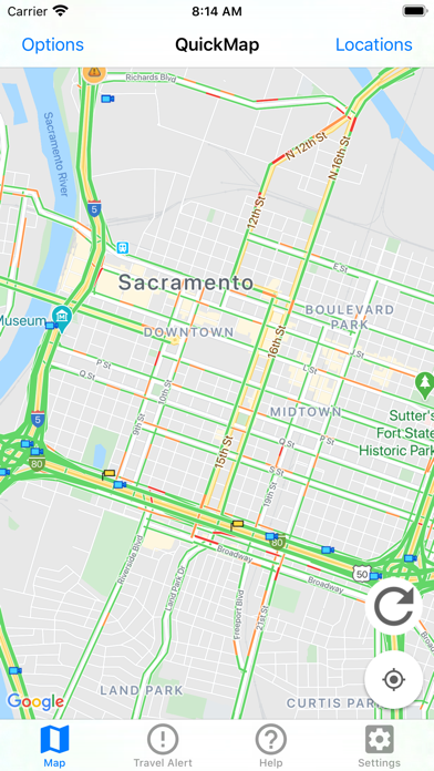
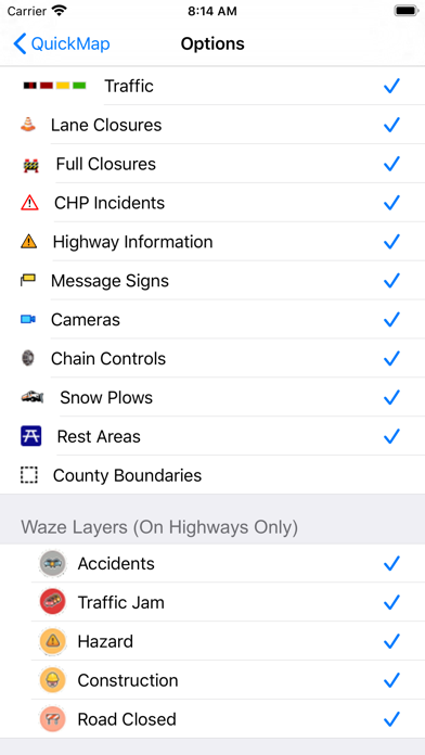
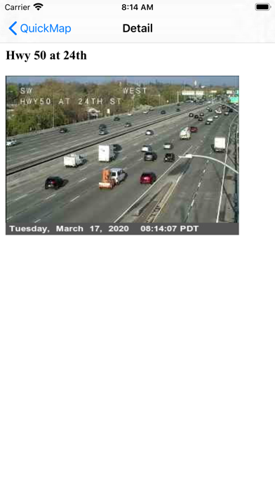
Get your California traffic information directly from the source. The Caltrans QuickMap app displays a map of your location along with real-time traffic information including:
- Freeway speed
- Traffic camera snapshots
- Lane closures
- CHP incidents
- Highway Information
- Changeable message signs
- Chain controls
- Snow Plows
- County Boundaries
- Border Wait Times
- Safety Roadside Rest Areas
- Waze data
Set which of these options to display and QuickMap will remember your preferences. Zoom to a view of other parts of California with the Location button. Click on traffic camera icons to see a camera image. Click on a CHP, lane closure, changeable message sign or chain control icon to view details for that marker.
Traffic data is updated every few minutes. Load the latest data on the map using the Refresh button.
If you choose to enable Geotargeted Notifications, this app will monitor your location in the background and alert you (via a Push Notification) to State Highway System road closures occurring near you. Continued use of background location may decrease battery life.
Something not right with the data displayed on the map? Please send us an email to [email protected] rather that letting us know with a low-rated review.
{{descriptionMoreText}}
Comments (0)
{{commentText.length}}/{{maxCommentText}}
{{commentError}}{{commentUserError}}
-
{{comment.commentUser.substring(0, 1)}}By {{comment.commentUser}}{{comment.commentDateString}}

Category Top
apps
- Google Play
- App Store


More Apps


