


 Art & Design
 Auto & Vehicles
 Beauty
 Business
 Education
 Entertainment
 Finance
 Food & Drink
 Health & Fitness
 House & Home
 Libraries & Demo
 Lifestyle
 Maps & Navigation
 Medical
 Music & Audio
 Parenting
 Personalization
 Photography
 Productivity
 Shopping
 Social
 Sports
 Tools
Tools Travel & Local
 Video Players
 Weather
 Family


 Fires - Wildfire Maps and Info
OS :
Version :3.4.3
Size :41.13Mb
Updated :Aug 14,2022
Developer :Ryan Strouse
 Ask AI
You can ask
the AI some questions about the app
Here are three potential topics that users might discuss about the Fires! Wildfire Maps and Info app:
1. How do you ensure the accuracy of the maps and data within the app?
2. What features do you use most frequently and why?
3. Have you found the app helpful in avoiding or preparing for wildfires in your area?
 Ask AI
Pros and Cons from users' feedback
Based on the users' reviews on the Apple App Store, here are three pros and three cons:
**Pros:**
1. Accurate and timely wildfire information helps users stay informed and prepared.
2. Comprehensive map features provide detailed views of fire locations and perimeters.
3. User-friendly interface makes it easy to navigate and find necessary information quickly.
**Cons:**
1. Some users reported issues with slow loading times and buffering on certain devices.
2. Limited functionality compared to other apps, with fewer features and customization options.
3. Occasional inaccuracies in fire data and mapping, causing frustration and confusion.
App
Downloads
<
>


App
Survey
-
Application interactivity Does it affect the experience?
-
Application technology innovation Does it affect the experience?
-
Does the update frequency of the application affect the experience?
-
Does the feedback of the application affect the experience?
Description
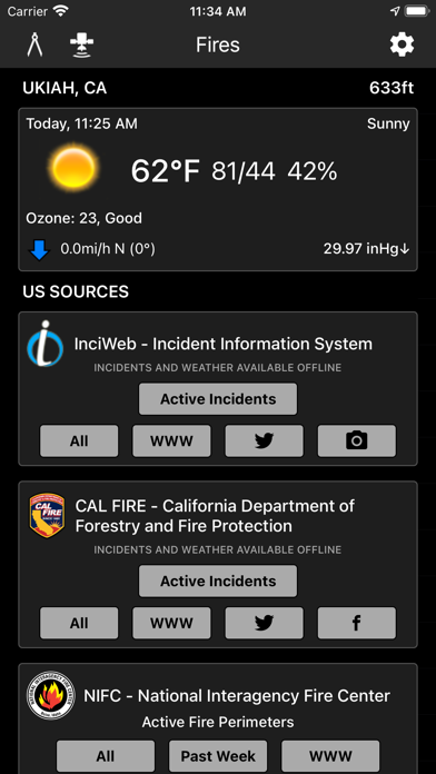
Fires is a comprehensive wildfire information resource and navigation app.
▶▶ WILDFIRE INFORMATION RESOURCE
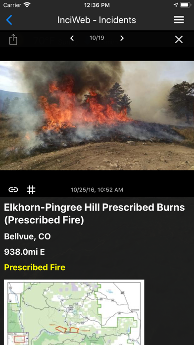
▶ Incident Details
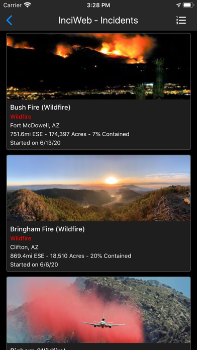
Fires provides maps, photos, and information about wildfires from several sources for the United States. View active wildfire perimeters or share wildfire information and high resolution photos.
• InciWeb
• CAL FIRE
• NIFC
• US Forest Service
▶ Incident Notifications with Containment Updates and Fire Weather Notifications
Fires will notify you when new incidents are downloaded within the maximum distance that you set from the source that you select.
• InciWeb
• CAL FIRE
• US Forest Service
▶ Offline Incident Mapping
Fires can automatically download incidents when the app is in the background from the source that you select.
• InciWeb
• CAL FIRE
• US Forest Service
▶ Thermal Hotspots and Fire Activity
Fires allows you to interactively browse the full set of global active fire detections from MODIS and VIIRS.
• Collection-6 MODIS Active Fire Data
• VIIRS I-Band 375m Active Fire Data
• Active Fire Details
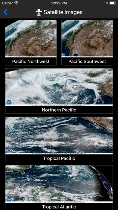
▶ GOES and Himawari Satellite Images and Animations
Fires provides extensive near real-time GOES (Geostationary Operational Environmental Satellite) imagery from NOAA.
• United States
• Pacific
• Atlantic
• Central America
• South America
• East Full Disk
• West Full Disk
▶ Local Weather Conditions
Fires gives you a summary of your current local weather conditions from AccuWeather for free without a subscription.
▶ Fire Weather Forecasts & Outlooks
Fires provides Fire Weather Forecast & Outlook maps intended to delineate areas of the US.
• Expected Number of Large Fires per PSA
• Fire Potential Index Forecast
• Fire Danger Rating
• Large Fire Probability
• National Significant Wildland Fire Potential Outlook
• Drought Monitor Summary
• Dead Fuel Moisture
▶ Historical Fires
Fires provides maps, photos, and information about historical wildfires from CAL FIRE for 2017-2020, and quick access to historical fire perimeters from 2000-2018.
▶ Social Media Updates
Fires provides quick access to social media updates from national and state agencies.
• Twitter
• Facebook
• Instagram
▶▶ NAVIGATION APP
▶ Offline 3D Maps and GPS
Fires will give you offline GPS functionality and 3D base maps when there is no network coverage. Fires allows you to cache what you use and doesn't require you to manually save your maps, which saves you a lot of time.
• Several Base Maps
• Create Lines, Shapes, and Waypoints
• Navigate and trace your locations
▶▶ SUBSCRIPTIONS
Subscriptions automatically renew unless auto-renew is turned off at least 24 hours before the end of the current period. Your iTunes account will be charged for renewal within 24 hours of the end of the current period, and identify the cost of the renewal.
▶ FIRES PRO ($14.99/year)
• Access Satellite Hybrid base map
• Access Topo base map
• Access Streets base map
• Access Hillshades overlay
• Access Incident Weather Conditions
• Remove Ads
▶ SATELLITE BASE MAP ($4.99/6 months)
• Access Satellite (No Labels) base map
▶ INCIDENT WEATHER CONDITIONS ($5.99/year)
• Access Incident Weather Conditions
▶ REMOVE ADS ($2.99/year)
• Use the app without ads
▶ TO MANAGE YOUR SUBSCRIPTION:
• TURN OFF auto-renewal via the main Settings app: http://support.apple.com/kb/ht4098
• Subscriptions automatically renew unless auto-renew is turned off at least 24 hours before the end of the current period. Your iTunes account will be charged for renewal within 24 hours of the end of the current period, and identify the cost of the renewal.
• Your iTunes Account will be charged at confirmation of purchase.
• Visit the following URL to view our Privacy Policy: http://www.livewaremedia.com/p/privacy-policy.html
• Visit the following URL for full terms of use: http://www.livewaremedia.com/p/terms-and-conditions.html
{{descriptionMoreText}}
Comments (2)
{{commentText.length}}/{{maxCommentText}}
{{commentError}}{{commentUserError}}
-
{{comment.commentUser.substring(0, 1)}}By {{comment.commentUser}}{{comment.commentDateString}}
-
ABy AireAnna RoseAug 28,2020
-
KBy Knuckles049IHJul 13,2021
Category Top
apps
- Google Play
- App Store


More Apps


