


 Art & Design
 Auto & Vehicles
 Beauty
 Business
 Education
 Entertainment
 Finance
 Food & Drink
 Health & Fitness
 House & Home
 Libraries & Demo
 Lifestyle
 Maps & Navigation
 Medical
 Music & Audio
 Parenting
 Personalization
 Photography
 Productivity
 Shopping
 Social
 Sports
 Tools
Tools Travel & Local
 Video Players
 Weather
 Family


 My Altitude
OS :
Version :2.8.3
Size :64.08Mb
Updated :Jun 21,2022
Developer :Dayana Networks Ltd
 Ask AI
You can ask
the AI some questions about the app
Here are three topics that users may discuss about the "My Altitude" app, turned into questions for you:
1. What features do you like most about the app's altitude tracking and logging capabilities?
2. How has the app helped you improve your outdoor activities, such as hiking or flying, with its altitude data?
3. Are you satisfied with the app's accuracy and reliability in providing altitude readings, and if not, what improvements would you suggest?
 Ask AI
Pros and Cons from users' feedback
I'd be happy to help you with that! After analyzing the user reviews on the Apple App Store, here are three pros and three cons of the "My Altitude" app:
Pros:
1. Accurate tracking: Users praise the app's ability to accurately track their altitude and provide precise data.
2. Easy to use: Many reviewers find the app's interface user-friendly and easy to navigate.
3. Helpful for outdoor activities: Users appreciate the app's usefulness for tracking altitude during outdoor activities like hiking, climbing, and skiing.
Cons:
1. Limited features: Some users feel that the app lacks additional features, such as GPS tracking or weather integration.
2. Glitches and bugs: A few reviewers experience glitches and bugs that affect the app's performance and accuracy.
3. Limited compatibility: Some users report
App
Downloads
<
>

App
Survey
-
Why do you uninstall an app?
-
Application technology innovation Does it affect the experience?
-
Ease of use of the application Does it affect the experience?
-
What is your Mobile System?
Description
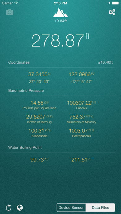
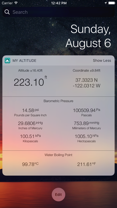
My Altitude uses GPS signals to determine your current location, showing your latitude, longitude and altitude (height from sea level) barometric pressure and water boiling point.
It's a free app and does not have any limitations. In-App purchase can be used to remove the bottom advertisement and to support us.
This application does not need an internet connection and works best in outdoors.
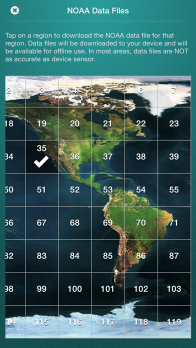
By default, it uses device sensor to determine the elevation from see level, but you also have the option to use NOAA data files to get the altitude of your location. On newer devices, using device sensor is more accurate.
It also allows you to get a picture of where you are and save it in photo album. Picture will be sealed with coordinates of current location along with altitude and local date/time.
Barometric Pressure is calculated based on elevation. On newer devices such as iPhone 6/6+ value is being delivered directly from device built-in barometric sensor, this behavior is configurable and you can switch back to calculation mode.
App Features:
- Elevation from see level in meter (metric) or feet (imperial)
- Change between metric and imperial systems by tapping on reported elevation
- Current location coordinates including latitude and longitude
- Barometric pressure in various units extracted from device sensor or calculated from altitude
- Water boiling point at your current location
- Current weather information including temperature, condition, humidity, wind speed and wind bearing
- World Altitude, get approximate altitude (elevation from see level) of any location in the world
- Save altitude data for reference
- Take a picture and watermark it with elevation information and share
Enjoy.
{{descriptionMoreText}}
Comments (2)
{{commentText.length}}/{{maxCommentText}}
{{commentError}}{{commentUserError}}
-
{{comment.commentUser.substring(0, 1)}}By {{comment.commentUser}}{{comment.commentDateString}}
-
ABy Ajith TechmanDec 18,2019
-
sBy skm1209Sep 9,2020
Developer apps
 Stream Server
 Box Inventory
 NSLookup Plus
 Pro Leveler
 Personal Web Server
 ESP Home
 Audio Stream Player
 Lecture Pro
 GPS Trip Tracker
 Control Panel Plus
 Cloud Media Player
 Offline Reader Pro
 Control Panel Pro
 Video Record Pro
 Voice Record Pro 7 Full
 iMP3
iMP3 Network Utilities & Analyzer
 NSLookup
 Jigsaw Puzzle Game Pro Classic
 Farda Station - ایستگاه فردا
 Voice Record Pro 7
 Dish Align
 Voice Record Pro
Category Top
apps
- Google Play
- App Store


More Apps


